


A postal code is the general term for a mail-sorting code used in many countries, while a ZIP Code is the postal code system used by the United States. So, if you are asking "is postal code same as ZIP code?", the practical answer is: not exactly - use "postal code" for the global concept and "ZIP Code" for US addresses.
This distinction is important for international addresses, where postal code names, formats, and rules vary by country. For apps that need to parse, complete, or geocode addresses across countries, tools such as the Geoapify Geocoding API and Address Autocomplete can help handle postal codes in a country-aware way.
On this page
ZIP Code vs Postal Code: Key Difference
The difference is simple: ZIP Code is the United States name for its postal code system. Postal code is the general term for similar codes used in other countries.
| Term | Meaning | Where it is used | Examples |
|---|---|---|---|
| Postal code | General term for a mail-sorting code in an address | Canada, UK, Germany, India, and many other countries | M5H 2N2SW1A 1AA10115 |
| ZIP Code | A postal code system used by the United States Postal Service | United States and US addresses | 100019021010001-1234 |
Even when the local name is different, the address component is still a postal code by nature. For international products, forms, and databases, you can usually keep a single postal code field internally, then adapt the user-facing label by country: "ZIP Code" in the United States, "postcode" in the United Kingdom, "postal code" in Canada, "PIN code" in India, "Eircode" in Ireland, "Postleitzahl / PLZ" in Germany, and "CAP" in Italy.
What Is a Postal Code?
A postal code is a country-specific code added to an address for mail sorting and delivery.


Depending on the country, a postal code can identify:
- A delivery area or postal route, as in the United States or Australia
- A town, district, or neighborhood, as in Germany
- A building, organization, PO box, or group of addresses, as in Canada or the United Kingdom
Its exact meaning depends on the local postal system. Some postal codes cover broad areas, while others point to much smaller delivery units, which is why postal codes are also useful for address forms, validation, geocoding, and location-based data workflows.
Meaning
A postal code is an address code used by a postal system to organize delivery. Its main purpose is to help sort, route, and deliver mail. It usually represents a geographic or delivery-related area, but it is not always a precise boundary on a map.
For example:
M5H 2N2is a Canadian postal code in Toronto.SW1A 1AAis a UK postcode in London.10115is a German postal code in Berlin.
Format
Postal code formats vary by country. Some countries use only numbers, while others use letters and numbers together.
| Country | Local name | Example format |
|---|---|---|
| Canada | Postal code | A1A 1A1 |
| United Kingdom | Postcode | AA9A 9AA |
| Germany | Postleitzahl / PLZ | 10115 |
| India | PIN code | 110001 |
See postcode formats around the world for a broader country-by-country guide.
Because formats differ, postal-code validation should be country-aware. A pattern that works for Germany will not work for Canada or the United Kingdom.
What Is a ZIP Code?
A ZIP Code is the United States postal code used by the United States Postal Service to sort and deliver mail. ZIP Codes are part of US addresses and are written after the city and state, for example New York, NY 10001.
ZIP Codes are not the global name for postal codes. They are the US version of a postal code system, just as Canada uses postal codes and the United Kingdom uses postcodes.
Is a Postal Code the Same as a ZIP Code?
No, not exactly. A ZIP Code is a postal code used in the United States, but postal code is the broader term used for similar address codes in many countries.
If the address is in the United States, "ZIP Code" is the correct label. If the address is international, "postal code" is usually the safer general term, while the local label may be postcode, PIN code, Eircode, PLZ, CAP, or another country-specific name.
Meaning
ZIP stands for Zone Improvement Plan. The name was chosen for the five-digit USPS system introduced in 1963 because it suggested that mail would move faster when senders included the code. The phrase "ZIP Code" is credited to postal executive D. Jamison Cain, while postal inspector Robert Moon is commonly associated with the early routing idea behind the first three digits.
The name reflects the original goal of the system: make mail move faster through USPS sorting and delivery routes.


A ZIP Code can represent:
- A delivery area served by a post office or postal route
- A group of addresses in a city, town, or rural area
- A high-volume recipient, such as a company, university, or government office
- A PO box group or military mail destination
For example:
10001is a ZIP Code in New York, NY.90210is a ZIP Code in Beverly Hills, CA.20500is the ZIP Code used for the White House in Washington, DC.
Format
US ZIP Codes are numeric. The standard format has five digits, and the extended ZIP+4 format adds four more digits after a hyphen.
| Format | Example | Meaning |
|---|---|---|
| Five-digit ZIP Code | 10001 | Standard ZIP Code for a delivery area |
| ZIP+4 Code | 10001-1234 | More specific delivery segment within a ZIP Code |
For address forms, store ZIP Codes as text, not numbers. Some valid ZIP Codes start with 0, and numeric storage can remove the leading zero.
ZIP Code vs ZIP+4
A five-digit ZIP Code identifies the main postal delivery area. A ZIP+4 Code adds four extra digits to narrow that area to a smaller delivery segment.


| Type | Format | What it identifies | Main use |
|---|---|---|---|
| ZIP Code | 10001 | Main USPS delivery area | Standard address forms and general mail delivery |
| ZIP+4 | 10001-1234 | More specific USPS delivery segment, such as a block, apartment group, PO box group, business, organization, or high-volume recipient | USPS-level sorting, routing, and mailing precision |
The practical difference is that a ZIP Code is easy for users to provide, while ZIP+4 is more precise but harder to collect and maintain. For most user-facing forms, the five-digit ZIP Code is enough.
ZIP+4 has a few disadvantages:
- Many people do not know their ZIP+4 without looking it up.
- It is longer than a ZIP Code and easier to mistype.
- It usually cannot be derived from the five-digit ZIP Code alone.
- It depends on the full mailing address, including street, building, apartment, PO box, or organization.
- It is less stable than a five-digit ZIP Code. A regular ZIP Code can stay the same for many years, while ZIP+4 can change when USPS updates address records, delivery routes, PO box assignments, or high-volume delivery points.
- It is designed for USPS mailing precision, not for maps, regional statistics, or international address forms.
Use ZIP+4 when your product specifically needs:
- USPS-level mailing precision
- Address standardization against reliable USPS-compatible data, such as in a USPS address verification workflow
- Bulk mailing, postage, or delivery-point workflows
For store locators, weather lookup, delivery estimates, demographic analysis, regional statistics, maps, or international forms, ZIP+4 usually adds little value. Treat it as USPS-specific mailing data, not as a stable general location field or geographic boundary.
See US ZIP Codes: Explore and Download for Free for more detail about ZIP Codes, ZIP+4, and ZIP Code Tabulation Areas.
Related Terms: Postcode, PIN Code, Eircode, CAP
Postal-code terminology changes by country. These terms are local names for national postal-code systems.
| Term | Where it is used | What it means |
|---|---|---|
| Postcode | United Kingdom and several other countries | A local name for a postal code |
| PIN code | India | Postal Index Number, the Indian postal-code system |
| Eircode | Ireland | Ireland's postcode system, designed to identify individual addresses more precisely |
| Postleitzahl / PLZ | Germany | The German postal-code system |
| CAP | Italy | Codice di Avviamento Postale, the Italian postal-code system |
| Código postal | Spain and many Spanish-speaking countries | Spanish term for postal code |
| CEP | Brazil | Código de Endereçamento Postal, the Brazilian postal-code system |
For international address forms, use these terms as country-specific labels, not as separate global address fields. Internally, a single postal_code field is usually enough, while the visible label can change by country.
How Geocoding Works with ZIP Codes and Postal Codes
Geocoding connects postal address data with coordinates. For ZIP Codes and postal codes, this means you can search by a code and get related location data, or start from coordinates and find the ZIP Code or postal code associated with that place.
There are Geoapify APIs that let applications work with ZIP Codes, postcodes, and other postal-code systems directly. Depending on the request, they can return coordinates, cities, districts, streets, address components, boundaries, or other places associated with a postal code.
| API | Best for | How it works with ZIP Codes and postal codes |
|---|---|---|
| Geocoding API | Converting addresses, ZIP Codes, postal codes, or place names into coordinates | Finds locations from text input and returns structured address components, including postal code fields when available |
| Address Autocomplete API | Helping users complete address forms while they type | Suggests postal-code-aware addresses, cities, streets, and places based on partial input |
| Postcode API | Searching and working directly with postal codes | Looks up postal codes, returns related locations, and supports postcode-focused search tasks |
Here are common examples of ZIP Code and postal code tasks in geocoding workflows:
Search by ZIP Code
To search for a US ZIP Code, use the code as the search text and restrict the request to the United States. The country filter is important because postal codes are not globally unique, and the same number can exist in different countries.
With the Geocoding API, you can search for ZIP Code 78660 like this. Use type=postcode to tell the API that you are looking for a postal-code result, not a street, city, or place name:
https://api.geoapify.com/v1/geocode/search?text=78660&type=postcode&filter=countrycode%3Aus&format=json&apiKey=YOUR_API_KEYYou can also use the Postcode API when the postcode itself is the main input. Add geometry=original when you need the ZIP Code geometry:
https://api.geoapify.com/v1/postcode/search?postcode=78660&countrycode=us&geometry=original&apiKey=YOUR_API_KEY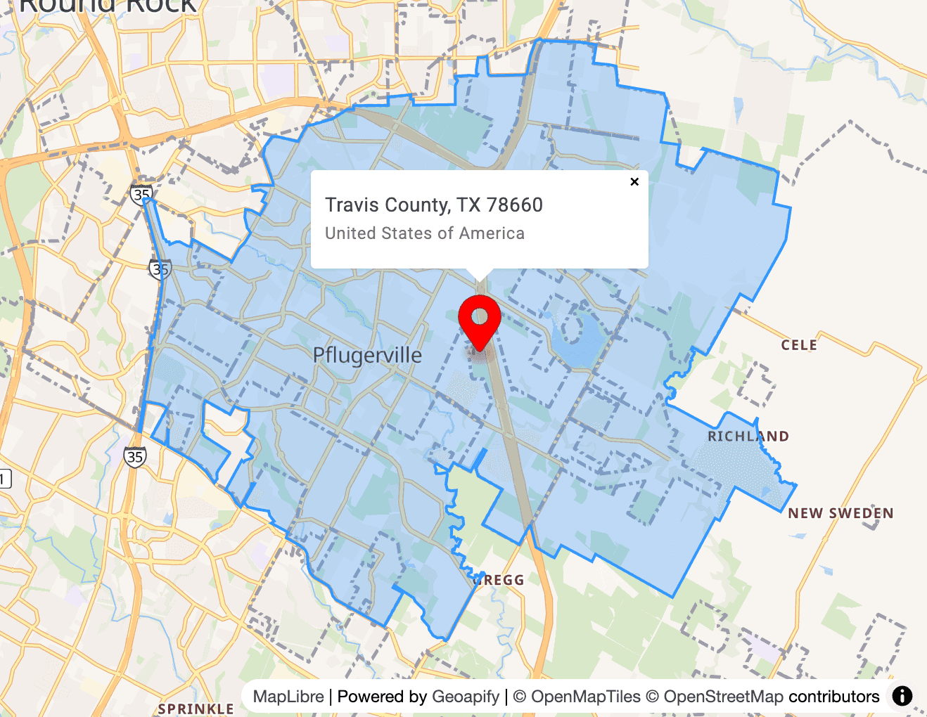
The response can include the ZIP Code, coordinates, country, state, county, formatted address, timezone, and geometry:
{
  "type": "FeatureCollection",
  "features": [
    {
      "type": "Feature",
      "properties": {
        "postcode": "78660",
        "lon": -97.5946865,
        "lat": 30.4396304,
        "country": "United States",
        "country_code": "us",
        "state": "Texas",
        "county": "Travis County",
        "formatted": "Travis County, TX 78660, United States of America",
        "timezone": {
          "name": "America/Chicago"
        }
      },
      "geometry": {
        "type": "Polygon"
      },
      "bbox": [-97.671594, 30.383341, -97.523051, 30.500864]
    }
  ]
}
Search by Postal Code
Searching by postal code works the same way as searching by ZIP Code. The main difference is that the postal code belongs to another national postal system, so it is recommended to set the country in the request.
For example, to search for postal code 78600 in Germany, use type=postcode and countrycode:de with the Geocoding API:
https://api.geoapify.com/v1/geocode/search?text=78600&type=postcode&filter=countrycode%3Ade&format=json&apiKey=YOUR_API_KEYOr use the Postcode API with countrycode=de:
https://api.geoapify.com/v1/postcode/search?postcode=78600&countrycode=de&apiKey=YOUR_API_KEYThe country is especially important for numeric postal codes because the same number can be valid in more than one country.
Search ZIP Code or Postal Code by Coordinates
When you already have coordinates, use reverse geocoding to find the ZIP Code or postal code associated with that location. This is useful for maps, GPS-based search, delivery zones, local search, and analytics.
With the Reverse Geocoding API, set type=postcode to focus the result on the ZIP Code or postal code around the coordinates:
https://api.geoapify.com/v1/geocode/reverse?lat=38.612369344552974&lon=-121.3911257569456&type=postcode&format=json&apiKey=YOUR_API_KEYYou can also use the Postcode API with coordinates. Add geometry=original when you need the postal code geometry and it is available:
https://api.geoapify.com/v1/postcode/search?lat=38.612369344552974&lon=-121.3911257569456&geometry=original&apiKey=YOUR_API_KEYAutosuggest Postcode
Use autocomplete when users start typing a ZIP Code or postal code and you want to suggest matching codes before they enter the full value. Set type=postcode so the Address Autocomplete API returns postcode suggestions instead of general addresses or places.
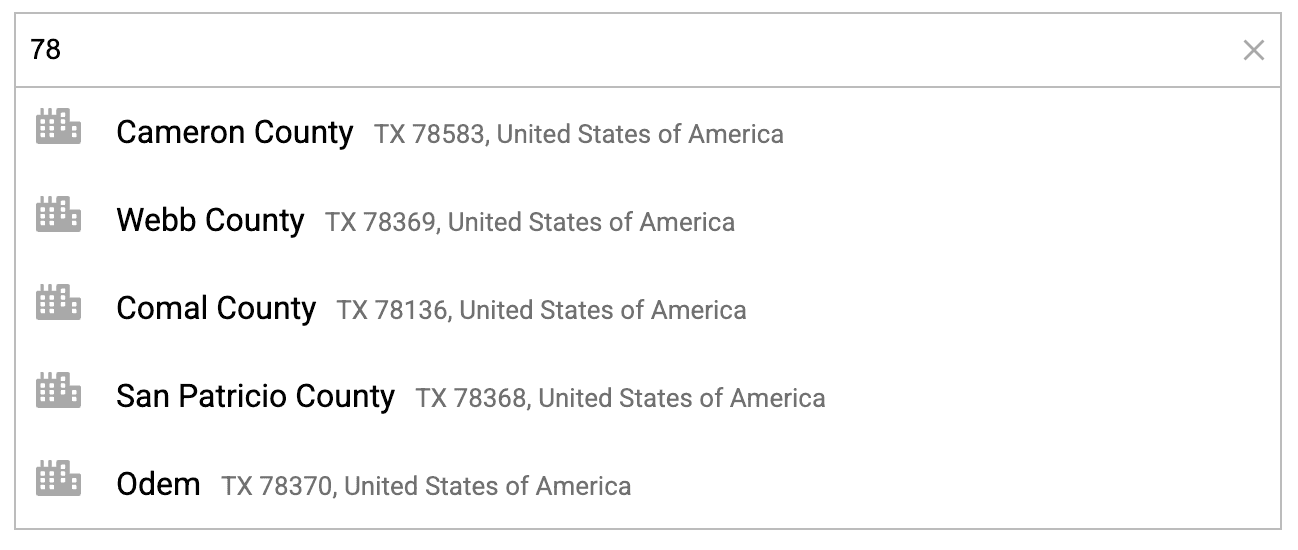
For example, this request suggests US ZIP Codes that start with 78:
https://api.geoapify.com/v1/geocode/autocomplete?text=78&type=postcode&limit=5&filter=countrycode%3Aus&format=json&apiKey=YOUR_API_KEYImportant parameters:
text=78is the partial ZIP Code or postal code typed by the usertype=postcodelimits suggestions to postal-code resultslimit=5controls how many suggestions are returnedfilter=countrycode:usrestricts suggestions to one countryformat=jsonreturns a compact JSON response
Autosuggest Cities for a Postcode
You can also use autocomplete to suggest cities related to a ZIP Code or postal code. In this case, use the postal code as the input text and set type=city so the API returns city-level results instead of postcode records.
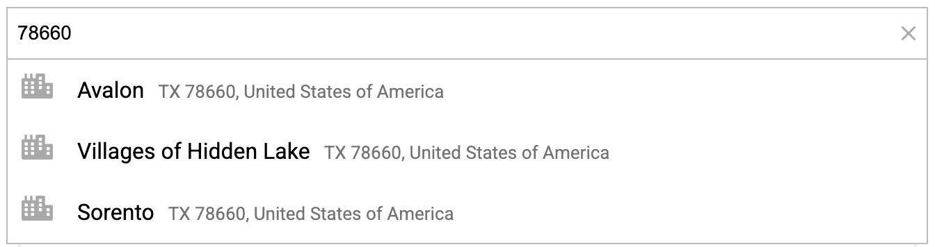
For example, this request suggests US cities related to ZIP Code 78660:
https://api.geoapify.com/v1/geocode/autocomplete?text=78660&type=city&limit=5&filter=countrycode%3Aus&format=json&apiKey=YOUR_API_KEYImportant parameters:
text=78660is the ZIP Code or postal code used as the search inputtype=citylimits suggestions to city-level resultslimit=5controls the number of suggestionsfilter=countrycode:usrestricts the search to the United States
List ZIP Codes or Postal Codes for Text
Use the Postcode API list endpoint when you need a list of ZIP Codes or postal codes that match a text fragment. This is useful for search interfaces, admin tools, and postcode pickers where the user enters only part of the code.
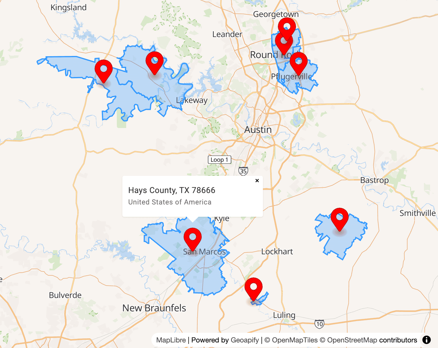
For example, this request lists US ZIP Codes that match 7866 and returns geometry when available:
https://api.geoapify.com/v1/postcode/list?countrycode=us&text=7866&limit=20&geometry=original&apiKey=YOUR_API_KEYImportant parameters:
countrycode=usrestricts the result to one countrytext=7866searches for postal codes matching the text fragmentlimit=20controls how many results are returnedgeometry=originalrequests postal-code geometry when it is available
List ZIP Codes or Postal Codes by Geometry
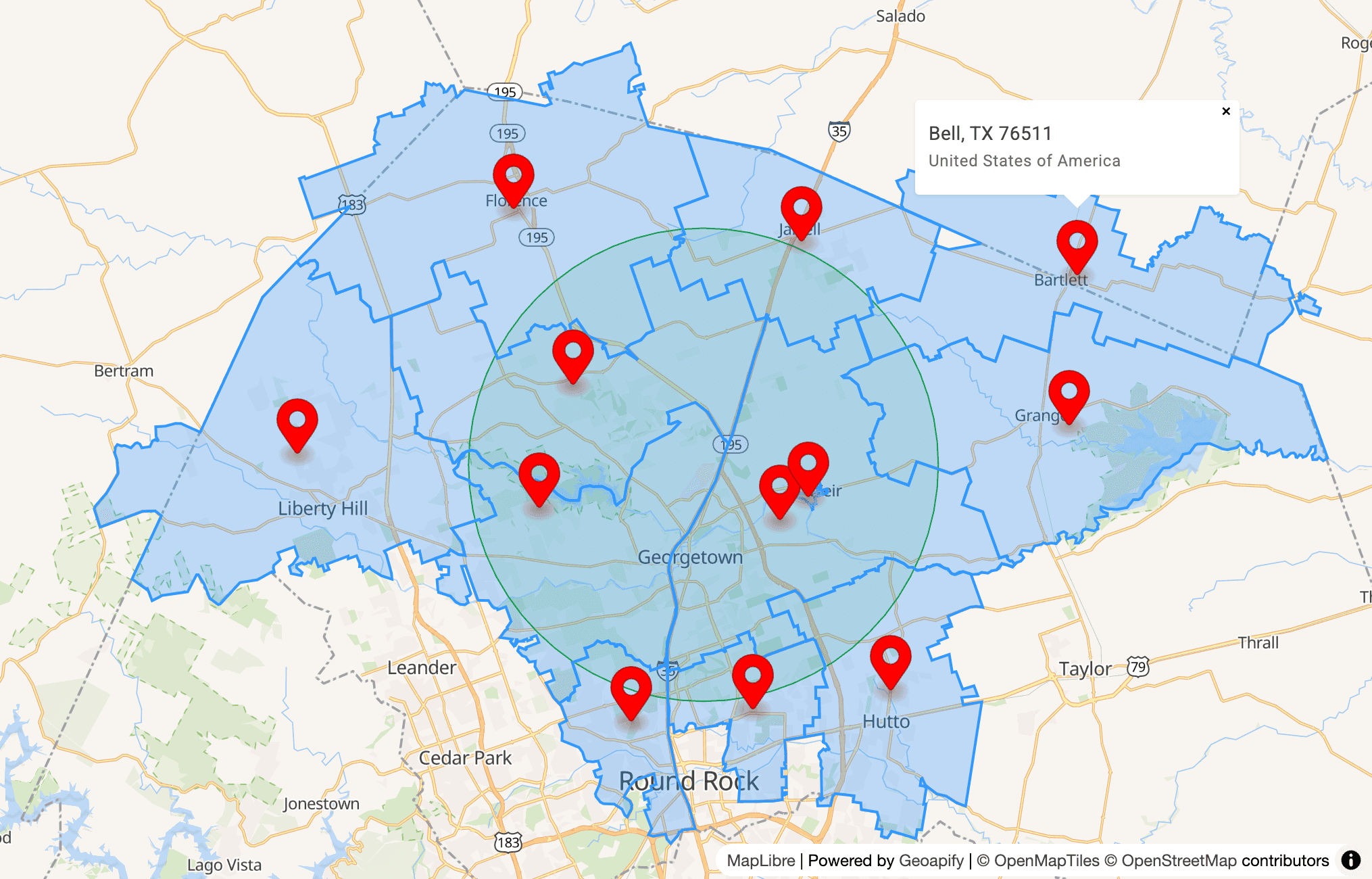
Use the Postcode API list endpoint with a geometry filter when you need ZIP Codes or postal codes within a specific area. For example, a circle filter can return postal codes around a coordinate within a given radius.
This request lists US ZIP Codes within 15 km of the specified coordinate and requests original geometry when available:
https://api.geoapify.com/v1/postcode/list?countrycode=us&limit=20&geometry=original&filter=circle:-97.66876187385702,30.68956874065597,15000&apiKey=YOUR_API_KEYImportant parameters:
countrycode=usrestricts the result to US ZIP Codesfilter=circle:-97.66876187385702,30.68956874065597,15000searches within a 15 km radius around the coordinatelimit=20controls how many ZIP Codes are returnedgeometry=originalrequests ZIP Code geometry when it is available
Best Practices for Using ZIP Codes and Postal Codes in Apps
ZIP Codes and postal codes look simple, but they are country-specific address data. Treat them as structured text fields, not universal numbers or exact map areas.
Store Postal Codes as Text
Store ZIP Codes and postal codes as strings, not numbers. Some valid codes start with 0, and numeric storage can remove leading zeros.
For example, 00501 is a valid US ZIP Code. If it is stored as a number, it can become 501, which is no longer the same postal code.
Always Use Country Context
Always store or request postal codes together with a country. Postal codes are not globally unique, and the same code can exist in more than one country.
Country context also helps choose the right format, label, validation rule, and API filter. For example, a form can show "ZIP Code" for the United States, "postcode" for the United Kingdom, and "PIN code" for India while keeping one internal postal_code field.
Do Not Treat Postal Codes as Exact Boundaries
Postal codes are designed for mail delivery, not precise mapping. Some postal codes have useful geometry, but others may represent routes, PO boxes, organizations, buildings, or delivery groups rather than clean administrative areas.
Use postal-code geometry when it is available and useful, but avoid treating every ZIP Code or postal code as an exact official boundary.
Use the Right API for the Task
Choose the API based on what your app needs:
- Use the Geocoding API to convert addresses, ZIP Codes, postal codes, or place names into coordinates
- Use the Reverse Geocoding API to find a ZIP Code or postal code from coordinates
- Use the Address Autocomplete API to suggest postal codes, cities, streets, and addresses while users type
- Use the Postcode API for postcode search, postcode lists, and postal-code geometry
Learn More
These related guides cover postcode formats, ZIP Code data, reverse geocoding, and address quality in more detail.


What are the correct postcode formats around the world?


How to Verify an Address with USPS (And When You Need an Address Validation API)


US ZIP Codes: Explore and Download for Free
FAQ
Is a postal code the same as a ZIP Code?
Not exactly. A ZIP Code is the postal code system used in the United States, while postal code is the general term for similar address codes used in many countries. For example, "10001" is a US ZIP Code, while "SW1A 1AA" is a UK postcode and "M5H 2N2" is a Canadian postal code.
Is ZIP Code used only in the United States?
ZIP Code is the United States Postal Service name for the US postal code system. For international addresses, use the local term when possible, such as postcode in the United Kingdom, postal code in Canada, PIN code in India, or Eircode in Ireland.
What should I use in an international address form: ZIP Code or postal code?
Use "postal code" as the internal field concept for international address data, and adapt the visible label by country. For example, show "ZIP Code" for the United States, "postcode" for the United Kingdom, and "PIN code" for India. For country-specific examples, see postcode formats around the world.
Can two countries have the same postal code?
Yes. Postal codes are not globally unique, especially numeric codes. That is why address forms, validation rules, and APIs should use the country together with the ZIP Code or postal code.
Can I get coordinates from a ZIP Code or postal code?
Yes. You can use the Geoapify Geocoding API to convert a ZIP Code or postal code into coordinates, or use the Postcode API when the postal code itself is the main search input.
Can I get a ZIP Code or postal code from coordinates?
Yes. Use the Reverse Geocoding API with the "type=postcode" parameter to find the ZIP Code or postal code near a latitude and longitude. The Postcode API can also search by coordinates and return postal-code geometry when available.
Are ZIP Code boundaries official map boundaries?
Not always. ZIP Codes are designed for mail delivery, not as exact administrative boundaries. Some ZIP Codes or postal codes have useful geometry, but they can represent delivery routes, PO boxes, organizations, or groups of addresses rather than clean map areas.
Should ZIP Codes and postal codes be stored as numbers?
No. Store ZIP Codes and postal codes as text strings. Some valid codes start with zero, and numeric storage can remove leading zeros. For example, "00501" can become "501" if it is stored as a number.