


Welcome to the comprehensive guide on US ZIP codes, your gateway to unlocking the geographical intricacies of the United States. ZIP codes, the numerical identifiers assigned to specific regions, play a pivotal role in our daily lives, impacting everything from mail delivery to market analysis.
In this guide, powered by Geoapify, we offer you the unique opportunity to not only explore but also download ZIP code data for free, empowering you with valuable insights into the diverse landscapes that make up the United States. Whether you're a developer, a data enthusiast, or someone keen on understanding the intricacies of location data, Geoapify provides the tools to enhance your exploration and utilization of ZIP code information.
Understanding US ZIP Codes
Since its inception on July 1, 1963, the United States ZIP Code system has been a cornerstone of geographical organization, providing a structured framework for efficient mail delivery and beyond.
The format, designated as US NNNNN, NNNNN-NNNN, is commonly known as the ZIP Code, encompassing both the standard five-digit version and the extended nine-digit ZIP+4 Code.
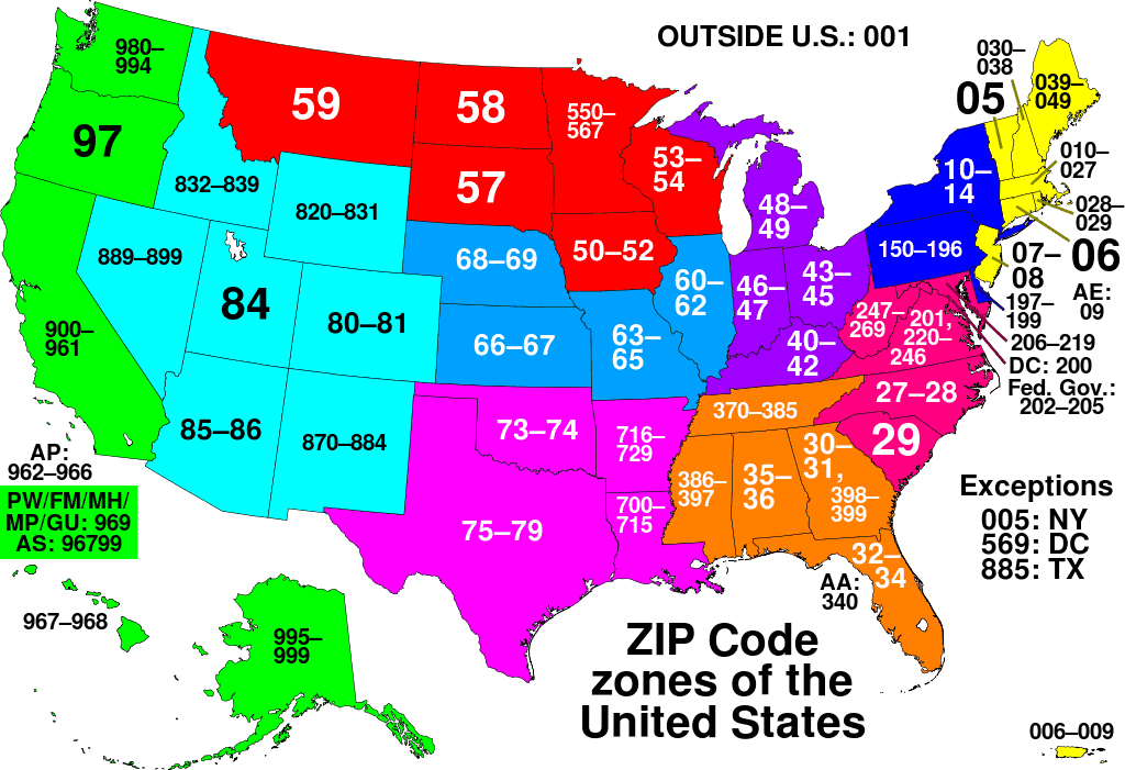
NNNNN ZIP Codes
Five digits ZIP codes adhere to a structured numbering system characterized by the following:
- The initial digit serves as a unique identifier for a specific group of U.S. states.
- The subsequent two digits provide representation for a distinct region within that state group, or, in some cases, a prominent city.
- Progressing further, the fourth and fifth digits pinpoint a cluster of delivery addresses within the specified region.
Notably, the primary town in a region typically receives the initial ZIP codes for that area. Subsequent ZIP codes for other towns are generally assigned in numerical order, maintaining a sequential pattern. Moreover, it's common practice to conclude the ZIP code for the largest city in a given prefix with the digits "01." This systematic approach streamlines the sorting and distribution process for mail and packages.
For additional information about ZIP code prefixes, you can refer to this Wikipedia page.
US Zip Codes are utilized not only within the continental United States but also extend their application to former US Pacific Territories, including the Federated States of Micronesia, Palau, and the Marshall Islands. Additionally, these codes are in use within current US territories such as American Samoa, Guam, Northern Mariana Islands, Puerto Rico, and the United States Virgin Islands:
| Territories | U.S. ZIP codes |
|---|---|
| Federated States of Micronesia | 96941 - 96944 |
| Palau | 96939, 96940 |
| Marshall Islands | 96960 - 96970 |
| American Samoa | 96799 |
| Guam | 96910 - 96932 |
| Northern Mariana Islands | 96950 - 96952 |
| Puerto Rico | 006XX, 007XX, 009XX |
| U.S. Virgin Islands | 00801 - 00851 |
NNNNN-NNNN ZIP Codes
In the United States, a 9-digit ZIP code is known as the ZIP+4 code. The standard 5-digit ZIP code is extended with an additional 4 digits separated by a hyphen. The first five digits represent a specific geographic area or address, and the additional four digits provide more precise information, often pinpointing a specific building or delivery point.
For example: 12345-6789
In this example, "12345" is the standard 5-digit ZIP code, and "6789" represents the additional 4 digits of the ZIP+4 code. The full ZIP+4 code offers a higher level of accuracy for mail delivery and sorting.
While the first five digits (standard ZIP code) are relatively stable for a given area, the last four digits can be subject to change as the postal service optimizes delivery routes and addresses. It's a good practice to verify the complete ZIP+4 code with the most up-to-date information, especially for precise mailings or deliveries.
ZIP Codes Tabulation Areas (ZCTAs)
ZIP Code Tabulation Areas (ZCTAs) are geographic entities defined by the U.S. Census Bureau to approximate the boundaries of ZIP Code areas for statistical analysis and data presentation. Unlike traditional ZIP Codes, which are designed for postal purposes, ZCTAs are specifically constructed to meet the demand for demographic and socio-economic data analysis.
Key characteristics of ZCTAs include:
- Approximate Boundaries: ZCTAs represent the approximate extent of ZIP Code areas and are constructed by aggregating Census blocks that align with the delivery areas of ZIP Codes.
- Statistical Analysis: ZCTAs are created to provide researchers and analysts with a geographic framework for statistical analysis. They enable the examination of demographic trends, socio-economic patterns, and other relevant data at the ZIP Code level.
- Census Data Representation: Census data is often provided for ZCTAs, making them a valuable resource for understanding population characteristics, housing trends, and other census-related information.
- Aggregation Process: The creation of ZCTAs involves combining Census blocks to form polygons that represent the approximate geographic scope of a ZIP Code area.
While ZCTAs serve as a useful tool for statistical purposes, it's important to note that they are approximations and may not perfectly align with the boundaries of USPS-assigned ZIP Codes. Despite this limitation, ZCTAs play a crucial role in providing researchers and policymakers with a standardized and consistent geographic unit for analyzing and presenting demographic data.
Download ZIP Codes Tabulation Areas (ZCTAs)
Download the ZCTAs dataset, conveniently available in JSON format, provides not just ZIP codes but comprehensive GeoJSON Polygon representations of their boundaries:
Importantly, this dataset is made available under the Open Government Licence (OGL), granting you the freedom to use, modify, and share the data for various purposes. Under the OGL, you are encouraged to leverage this valuable resource in a manner that fosters collaboration, innovation, and transparency in the spirit of open government initiatives.
Code samples
For your convenience, we've crafted a selection of code samples designed to facilitate the seamless integration of our ZIP Codes Tabulation Areas (ZCTAs) dataset into your projects. These code snippets are tailored to assist you in addressing specific business tasks, unlocking the full potential of geospatial data within your applications.
Read Zip Codes as a Json Array
The zip codes are conveniently formatted in Newline Delimited JSON (ndjson) format, allowing you the flexibility to read the entire file at once or row by row, based on your specific needs.
For your coding convenience, the example showcasing how to write this data was previously provided in our "Download Postal Codes By Country" article under the "Download ZIP Codes Tabulation Areas" section. This continuity ensures a smooth transition from downloading to reading and utilizing the ZIP code data within your applications.
Getting Zip Code Data and Geometry
Obtaining ZIP code data along with their corresponding geometries has never been easier:
const postcode = postcodes.find(item => item.postcode === '30038');
console.log(postcode.geometry);
The dataset includes GeoJSON Geometry, a widely supported format natively compatible with popular GIS and map libraries such as Leaflet, MapLibre GL, and OpenLayers.
Getting Zip Codes Within a Radius
Explore the next code sample for effortlessly retrieving ZIP codes within a specified radius. This code sample demonstrates how to filter ZIP codes within a specified radius from a given location (San Jose, California, USA). Feel free to adapt it to your specific use case or integrate it into your geospatial applications:
const latLonLocation = [37.324324, -121.848062]; // San Jose, California, USA
const radius = 10; // 10 km
const postcodesWithin = postcodes.filter(item => {
  const distanceToLocation = distance(latLonLocation[0], latLonLocation[1], item.lat, item.lon, 'K');
  return distanceToLocation < radius;
});

console.log(postcodesWithin.map(item => item.postcode));

// Distance calculation function sourced from GeoDataSource (https://www.geodatasource.com/developers/javascript)
function distance(lat1, lon1, lat2, lon2, unit) {
	if ((lat1 == lat2) && (lon1 == lon2)) {
		return 0;
	}
	else {
		var radlat1 = Math.PI * lat1/180;
		var radlat2 = Math.PI * lat2/180;
		var theta = lon1-lon2;
		var radtheta = Math.PI * theta/180;
		var dist = Math.sin(radlat1) * Math.sin(radlat2) + Math.cos(radlat1) * Math.cos(radlat2) * Math.cos(radtheta);
		if (dist > 1) {
			dist = 1;
		}
		dist = Math.acos(dist);
		dist = dist * 180/Math.PI;
		dist = dist * 60 * 1.1515;
		if (unit=="K") { dist = dist * 1.609344 }
		if (unit=="N") { dist = dist * 0.8684 }
		return dist;
	}
}
Beyond the straightforward "within a radius" query, the dataset empowers you to perform more intricate calculations. For instance, you can precisely identify all ZIP codes whose geometries intersect with a circle of the provided radius. To implement this, advanced libraries such as Turf can be seamlessly integrated, offering a comprehensive solution for precise geospatial queries.
FAQ
How many ZIP Codes are there in the United States?
As of November 2023, there are 41,704 ZIP Codes in the United States.
What are ZIP Code Tabulation Areas (ZCTAs) and how are they created?
ZCTAs are approximate boundaries of ZIP Code areas created by the U.S. Census Bureau to satisfy demand for statistical data. The Census Bureau calculates these boundaries, providing latitude and longitude data for the center-points of ZCTAs. The process involves interpolating discrete ZIP Code data to create polygons for mapping and data presentation. ZCTAs face criticisms, including issues with Census blocks straddling multiple ZIP Codes, resulting in problems of dividing aggregate units. The creation of ZCTAs may commit the ecological fallacy by attempting to disaggregate aggregate data. Additionally, ZCTAs are not updated as frequently as USPS updates ZIP Codes, causing temporal analysis challenges. Despite the issues, ZCTAs remain popular, especially in fields like epidemiology and among government agencies.
What is the range of ZIP Codes in the United States?
ZIP Codes in the United States are structured with a five-digit format (e.g., 12345). The first digit is assigned regionally, and as you move through the five digits, the specificity of the geographic area increases. Additionally, ZIP+4 Codes include an extra four digits separated by a hyphen (e.g., 12345-6789), offering even more precise location information.
Are the last four digits of ZIP+4 Codes stable, or do they change?
The last four digits of ZIP+4 Codes are more specific, often referring to a particular building or delivery point. While the first five digits are relatively stable, the last four can change due to factors like changes in address assignments or logistical considerations.
How can I download the ZIP Codes Tabulation Areas (ZCTAs) dataset?
You can download the ZCTAs dataset directly from Census website or our platform by following the provided link. The dataset is available in JSON format, including GeoJSON Polygon representations of ZIP code boundaries.
Can I use the Free US ZIP code data for commercial purposes?
Yes, our ZIP code dataset is made available under the Open Government Licence (OGL). This license allows you to use, modify, and share the data freely, even for commercial purposes. Refer to the OGL terms for specific details.