


On this page
OpenStreetMap (OSM) is a free, open-source alternative to Google Maps. Built by a global community, it offers full access to raw geospatial data — ideal for developers and businesses who need flexibility, control, and cost efficiency. Services like Geoapify help make OSM easy to use in real-world applications.
In this article, we’ll explore what makes OpenStreetMap different, when it’s a better choice than Google Maps, and how you can use it in real-world applications.
About OpenStreetMap
OpenStreetMap (OSM) is often described as the "Wikipedia of maps." It’s a free, open, and global community-driven project with a clear mission: to map everything that matters. Just like Wikipedia, OSM allows anyone to add, edit, and use the data.
And it's important to say "data" — not just "maps" — because that's what OSM fundamentally is: a large, open geospatial database, freely available to everyone.
While OSM is widely used to render digital maps, its applications go far beyond that. OSM powers routing and navigation, geocoding (address lookup), place search, map analysis, and many other location-based services.
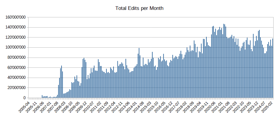
As of March 2024, OpenStreetMap had more than 10.5 million registered users and over 1.75 million active contributors. The database contains over 9.1 billion nodes, and approximately 4 million map changes are made each day — a scale unmatched by any commercial provider. You can find more statistics on the OpenStreetMap Wiki – Statistics page.
Tech giants like Facebook, Uber, and Microsoft rely on OSM data — meaning that, directly or indirectly, most of us are OSM users already.
Why OpenStreetMap Grows Faster Than Any Other Map
OpenStreetMap is not just a map — it’s a movement. Its success is rooted in the power of crowdsourcing, where local knowledge and global collaboration come together to build a better map of the world.
The crowdsourced revolution in mapping
When OpenStreetMap started in 2004, most digital map data was locked behind expensive licenses or government restrictions. Commercial providers controlled what could be mapped, how often it was updated, and who could access it.
By contrast, OpenStreetMap introduced a radically open model:
- Anyone could map their surroundings
- Data was immediately visible and reusable
- Licensing encouraged reuse and innovation
All you needed was a computer, an internet connection — and curiosity.
A community-driven revolution
OSM quickly attracted hobbyists, developers, researchers, and even humanitarian workers. As of March 2024, the project includes:
- Over 10.5 million registered users
- More than 1.75 million contributors
- Around 4 million map edits per day
- Over 9.1 billion nodes — and growing fast
And all of that is done by people — not corporations — contributing trails, roads, paths, rivers, bus stops, schools, and even benches and trees from every part of the world.
Even Google responded
In 2008, Google launched Google Map Maker, clearly inspired by OSM, to let users contribute local knowledge. But unlike OpenStreetMap:
- Google kept all rights to contributed data
- Changes were subject to manual review
- Data wasn’t openly accessible or downloadable
Map Maker was later shut down — but the lesson was clear: crowdsourcing works best when the data stays free.
Saving lives in real time
OpenStreetMap’s crowdsourcing model isn't just efficient — it's critical in emergencies. In 2010, after a devastating earthquake hit Haiti, volunteers from around the world rapidly mapped roads, shelters, and infrastructure using satellite images. Within days, responders had a map they could use — something no commercial provider could have delivered in time.
That response was led by the Humanitarian OpenStreetMap Team (HOT), which continues to coordinate crisis mapping efforts in disaster zones worldwide.
Instant updates, local knowledge
Unlike proprietary systems, OpenStreetMap updates are visible immediately — no waiting for review or approval.
This makes it ideal for:
- Rapidly changing areas
- New construction or infrastructure
- Mapping underserved or remote regions
And since contributors are often mapping their own communities, local accuracy is often better than what commercial maps provide.
Want to see live stats? Visit the OpenStreetMap Statistics Page or explore the OSM Wiki to learn more.
20 Milestones That Shaped OSM
From a student side project to the world’s most collaborative mapping platform — a visual journey through the events that built OpenStreetMap into the largest open geospatial project on the planet. This timeline highlights key breakthroughs, from the first website launch and early street edits to licensing changes, crisis response, and community growth.
Want to dive deeper? Explore the full History of OpenStreetMap on the official wiki.
OpenStreetMap.org Domain Registered
First Version of the Website Launched
First Street Added
First Mapping Party
1,000 Registered Users
JOSM 1.0 Released
First OSM Map on Wikipedia
OpenStreetMap Foundation Registered
Yahoo! Aerial Imagery Enabled
Rails Port and Potlatch Editor Launch
First State of the Map Conference
TIGER Data Import Begins
Haiti Earthquake Crisis Mapping
Bing Imagery Available
Switch to ODbL License
1 Million Registered Users
New iD Editor Becomes Default
Routing Feature Added to OSM.org
100,000,000th Changeset Submitted
10 Million Registered Users
Is OpenStreetMap Really Free to Use?
Yes — but it’s important to distinguish between the data itself and the services built on top of it.
The Data: Free and Open
The raw OpenStreetMap data is free to use under the Open Database License (ODbL). This means:
- You can download, use, and modify the data without cost.
- It can be used in commercial and non-commercial projects.
- Attribution to OpenStreetMap contributors is required.
- If you share modified data publicly, you must do so under the same open license.
Where to get the data:
- planet.openstreetmap.org – full worldwide OSM dataset (updated weekly)
- Geofabrik Downloads – regional extracts (Europe, Asia, countries, etc.)
- BBBike Extract Service – custom area downloads in multiple formats
- HOT Export Tool – exports for humanitarian and disaster response use
The Services: May Be Paid
Many tools and services built using OSM data — such as:
- Map tiles (rendered maps)
- Address geocoding and reverse geocoding
- Routing and navigation APIs
- Place search and spatial queries
— require server infrastructure, bandwidth, and ongoing maintenance. Because of this, service providers often charge for usage, especially at higher volumes or in commercial contexts.
Even OpenStreetMap’s own tile servers are only intended for limited personal use — not for business or high-traffic applications.
Products Based on OSM
OpenStreetMap isn’t just about raw data — it's the foundation for a wide range of powerful tools and platforms used across industries.
Mapping Platforms
These services use OSM data to power interactive maps and APIs:
- Mapbox – Customizable vector and raster maps with robust developer tools.
- Carto – Spatial data platform for geospatial analytics and visualization.
- MapTiler – Offers tile hosting, map styles, and offline maps based on OSM.
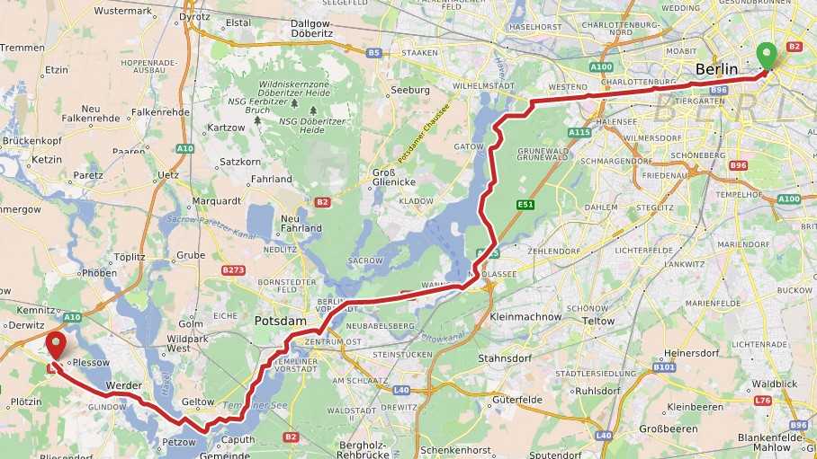
- Geoapify – Location platform with APIs for maps, geocoding, routing, and more.
Navigation & Routing Apps
- OsmAnd – Offline maps and navigation with customizable layers.
- Organic Maps – Lightweight privacy-focused navigation app using OSM.
- MAPS.ME – Popular offline travel maps built on OSM.
- GraphHopper – Java-based routing engine with a commercial cloud offering.
- OSRM (Open Source Routing Machine) – High-performance C++ routing engine.
- Valhalla – Open-source routing engine by Mapbox, supports multimodal transport.
Geocoding & Search
- Nominatim – The default open-source geocoder used by OSM.
- Geoapify Geocoding API – Production-ready geocoder with global coverage.
- LocationIQ – Scalable location APIs based on OSM data.
Humanitarian and Crisis Tools
- Humanitarian OpenStreetMap Team (HOT) – NGO supporting mapping for disaster and development response.
- HOT Export Tool – Custom data exports for offline and field use.
- Tasking Manager – Platform to coordinate large-scale volunteer mapping projects.
Custom Solutions
OpenStreetMap is used in:
- QGIS – Popular open-source GIS tool with OSM plugins.
- ArcGIS OSM Plugin – Enables working with OSM inside ArcGIS.
- Fitness & outdoor apps (e.g., Strava, Komoot)
- Real estate and mobility dashboards
- Drones, AVs, and robotics for map-based decision-making
OpenStreetMap vs Google Maps (Example of Proprietary Maps)
OpenStreetMap (OSM) and Google Maps offer similar functionality on the surface — interactive maps, place search, and routing. But under the hood, they follow two very different models.
Google Maps is a proprietary, commercial service. OSM is an open-source, community-driven project that powers countless apps, tools, and services — including commercial ones.
Here’s a comparison focused on what matters most for developers and businesses:
| Feature | OpenStreetMap (OSM) | Google Maps (Proprietary) |
|---|---|---|
| Cost | Free access to data; services like tile hosting or APIs may charge. Overall cost is typically much lower because you pay only for infrastructure. | Free for low usage; costs rise quickly at scale due to API usage fees and quotas. |
| License & Data Use | Open license (ODbL) — you can download, modify, store, reuse, and republish the data with attribution. | Strict terms — you cannot store, modify, or reuse Google’s map data outside their APIs. |
| Flexibility | Full freedom to use any tools, combine with other open or paid services, or self-host. Build completely custom apps or internal tools. | Locked into Google’s ecosystem and APIs; less control and no access to raw data. |
| Offline Use | Full offline support via raw data downloads and open-source apps (e.g., OsmAnd, Organic Maps). | Limited offline mode in mobile apps only; API services require a live connection. |
| Commercial Use | Excellent for commercial apps (e.g., delivery, logistics, travel, analysis). Great for white-label use. | Great for end-user apps needing polish, live services, and branding. |
| When Proprietary Wins | — | Needed if you require Street View, Live Traffic, or seamless integration with other Google services. |
So,
- OpenStreetMap is free, flexible, and developer-friendly. You can mix it with other tools, download and analyze the data, or build your own custom platform.
- Google Maps is polished and convenient, but its closed licensing, pricing, and lack of raw data access can be limiting for developers.
If you're building an app and want control, affordability, or innovation — OpenStreetMap is a great fit. And if you need a reliable API with hosting included, Geoapify offers OpenStreetMap-based services with a generous free tier.
How Geoapify Makes OpenStreetMap Easy for Developers and Businesses
OpenStreetMap is an incredible open dataset — but working with it directly means managing raw data, updates, tile servers, routing engines, and search indexes.
Geoapify solves this by offering ready-to-use APIs and SDKs that build on top of OpenStreetMap and other open data sources, such as:
These combined datasets enhance coverage, accuracy, and search quality while staying free and open under attribution-friendly licenses.
Why Choose Geoapify?
-
Hosted OpenStreetMap Maps Fully customizable tile maps with various styles (light, dark, outdoor, etc.), optimized for both web and mobile.
-
Search, Geocoding & Reverse Geocoding High-accuracy geocoding services using combined open sources. Includes autocomplete, partial address support, and localization.
-
Routing & Route Optimization Flexible Routing API for cars, bikes, pedestrians, trucks — plus advanced Route Optimization for delivery and logistics.
-
Based on Open Data — Not Just OSM Geoapify fuses OpenStreetMap with other open datasets for better results across regions and use cases.
-
Affordable & Transparent Pricing Free plan for development and small projects. Predictable pricing with no surprises.
-
Quick Start Tools No login needed to explore in the API Playground.
Whether you're building an internal dashboard, a global travel app, or a delivery system — Geoapify helps you launch faster using the power of open maps and data.
Final Thoughts: Open Maps, Open Opportunities
OpenStreetMap isn’t just a free alternative to Google Maps — it’s a powerful platform for innovation. Whether you're building an app, analyzing spatial data, or responding to real-world events, OSM offers the flexibility and transparency that proprietary platforms can't match.
And with services like Geoapify, you don’t need to choose between freedom and convenience. You get scalable, hosted tools built on open data — with a generous free plan and no vendor lock-in.
→ Explore all Geoapify APIs or Sign up for free to start today.
FAQ
What is OpenStreetMap?
OpenStreetMap (OSM) is a free, collaborative mapping platform built by volunteers around the world. It provides open geospatial data that can be used for maps, routing, geocoding, and spatial analysis.
Is OpenStreetMap really free to use?
Yes, OpenStreetMap data is free under the Open Database License (ODbL). You can download, modify, and use the data — even commercially — as long as you provide proper attribution and share modified datasets under the same license.
How is OpenStreetMap different from Google Maps?
Google Maps is a commercial, proprietary platform. OpenStreetMap is open-source and community-driven. With OSM, you get full access to raw map data and can use it flexibly, offline, or even combined with other tools — something not possible with Google Maps due to its restrictive license.
Can I build commercial apps with OpenStreetMap?
Absolutely. Many commercial apps use OSM — including navigation tools, logistics platforms, and real estate services. Just make sure you follow the attribution guidelines.
What are some services based on OpenStreetMap?
Popular services include Geoapify, Mapbox, GraphHopper, Nominatim, and OsmAnd. These provide APIs, routing, maps, and more — all based on OSM data.
Where can I download OpenStreetMap data?
You can download data from planet.openstreetmap.org, Geofabrik, or BBBike Extract. For custom data exports, try the HOT Export Tool.
What is Geoapify and how does it help?
Geoapify is a location platform that builds services on top of OpenStreetMap and other open datasets. It provides APIs for maps, geocoding, routing, and more — with a free plan and affordable pricing for developers and businesses.
Can I use OpenStreetMap offline?
Yes. You can download and use OSM data offline using tools like OsmAnd, Organic Maps, or your own custom apps built on downloaded data extracts.
Is OpenStreetMap accurate?
In many areas, especially in Europe and cities with active communities, OpenStreetMap is often more detailed than proprietary maps. The accuracy depends on local contributor activity and satellite imagery availability.
What types of data are included in OpenStreetMap?
OSM includes streets, paths, buildings, points of interest, addresses, administrative boundaries, and much more. Even benches, trees, and public toilets can be mapped.
How often is OpenStreetMap updated?
OpenStreetMap is updated in real time. As soon as a contributor submits a change, it becomes part of the live dataset — no manual approval or long delays required.