


Postcodes are a vital part of the UK's addressing system, essential for mail delivery, navigation, and location-based services. Understanding the structure and boundaries of UK postcodes is crucial for developers and data analysts working with geospatial data.
This article delves into the format of UK postcodes, the challenges in accessing accurate postcode data, and the process of creating boundaries for postcode outward parts and post towns. Additionally, it provides useful links for downloading postcode data and calculated boundaries, including resources from GeoNames and the Geoapify Geocoding, which leverages OpenStreetMap (OSM) data for precise geocoding services.
UK Postcode Format
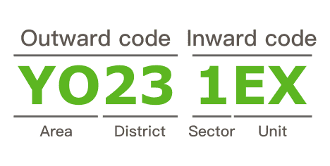
UK postcodes are alphanumeric strings that segment geographic areas into smaller, manageable units. UK postcodes vary in length, ranging from six to eight characters (including a space). Each postcode is divided into two parts separated by a single space: the outward code and the inward code.
-
Outward Code: This part identifies the postcode area and the postcode district.
- Postcode Area: The first one or two letters, representing a large area or city.
- Postcode District: The numbers that follow the postcode area, identifying a smaller geographic area within it.
-
Inward Code: This part identifies the postcode sector and the postcode unit.
- Postcode Sector: The first digit after the space, representing a further subdivision within the district.
- Postcode Unit: The final two letters, pinpointing a specific location, like a street or a small group of addresses.
In addition, in the UK postal system, post districts are grouped by post towns. A post town is a crucial component of all postal addresses in the United Kingdom and Ireland, serving as a fundamental unit of the postal delivery system.
For example, the post town "Yeovil" encompasses the post districts BA20, BA21, and BA22. This grouping helps streamline the sorting and delivery process, ensuring efficient and accurate postal service.
Challenges in Accessing UK Postcode Data
Accessing accurate UK postcode data can be challenging due to ownership and access restrictions imposed by Royal Mail. The Postcode Address File (PAF) is a comprehensive database containing all known delivery points and postcodes in the United Kingdom. It includes over 29 million postal addresses and 1.8 million postcodes.
However, accessing this data involves additional costs. Royal Mail charges for lookup services or wholesale supply of PAF data, with charges regulated by Ofcom. A significant limitation is that the PAF is only available to end-users, not data providers. This restriction means that original postcode data cannot be redistributed or integrated into third-party applications and services by data providers. This limitation poses a challenge for developers and analysts who need comprehensive postcode data for large-scale projects.
There have been ongoing requests as part of the Open Data campaign for the government to release the PAF free of charge. Advocates argue that making this data freely available would support innovation and development across various sectors. Despite these requests, the PAF remains a paid resource, posing a barrier for individuals and organizations needing comprehensive postcode data.
Overcoming the Challenges of Accessing UK Postcode Data
Despite the challenges posed by accessing accurate UK postcode data due to ownership and access restrictions by Royal Mail, there are ways to circumvent these issues. The growing popularity of the Open Data initiative has led to the development of alternative data sources that are freely available and highly useful.
One of the most significant alternatives is OpenStreetMap (OSM), a collaborative project that provides free geographic data. In OSM, postcodes are added as one of the attributes to buildings and amenities, offering detailed and continuously updated information.
Another valuable resource is GeoNames, an open-source project that compiles address data from global contributors. This project provides a rich dataset, including postal addresses and geographic coordinates.
Download All UK Postcodes Data
For those seeking comprehensive UK postcode data, GeoNames offers a valuable resource. This dataset is available under a Creative Commons Attribution 4.0 License, which means you can use the data as long as you provide appropriate credit to GeoNames.
The full postcode data is provided in a downloadable file named GB_full.csv.zip, which contains data sourced from Royal Mail. Note that while the data is freely available under the Creative Commons license, it retains Royal Mail's copyright and database rights for 2022.
By leveraging this dataset, developers and analysts can gain access to detailed postcode information, supporting various applications and research projects while adhering to the licensing terms.
Download Post Towns Data
For those needing comprehensive post town data, we have matched post town names with corresponding entities in OpenStreetMap (OSM). This dataset is available in ndjson format, with each row representing a post town.
The information includes geographical coordinates, boundary details when available, as well as the osm_id and osm_type for each post town.
The inclusion of osm_id and osm_type allows you to retrieve more detailed information about each post town using the Place Details API. For further information, you can visit the Place Details API. Here is an example of a request:
https://api.geoapify.com/v2/place-details?osm_type=r&osm_id=7205422&apiKey=YOUR_API_KEYThe dataset in the gb-post-towns.zip file is published under the Open Database License (ODbL), which allows you to freely share and modify the data as long as you attribute OSM and keep the data open.
This dataset allows developers and analysts to integrate post town information into their applications, supporting precise geospatial analysis and various other projects.
Download Outward Postcodes (First Part of the Postcode) Data
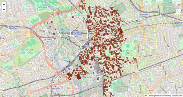
For those needing detailed information on the first part of UK postcodes, known as outward postcodes, we have calculated boundaries for these areas. Examples of outward postcodes include "SW1A", "YO23", and "L1". The dataset includes geographical boundaries, providing a clear visualization of each postcode area.
How We Calculated the Boundaries
To calculate the boundaries for outward postcodes, we followed a systematic process:
-
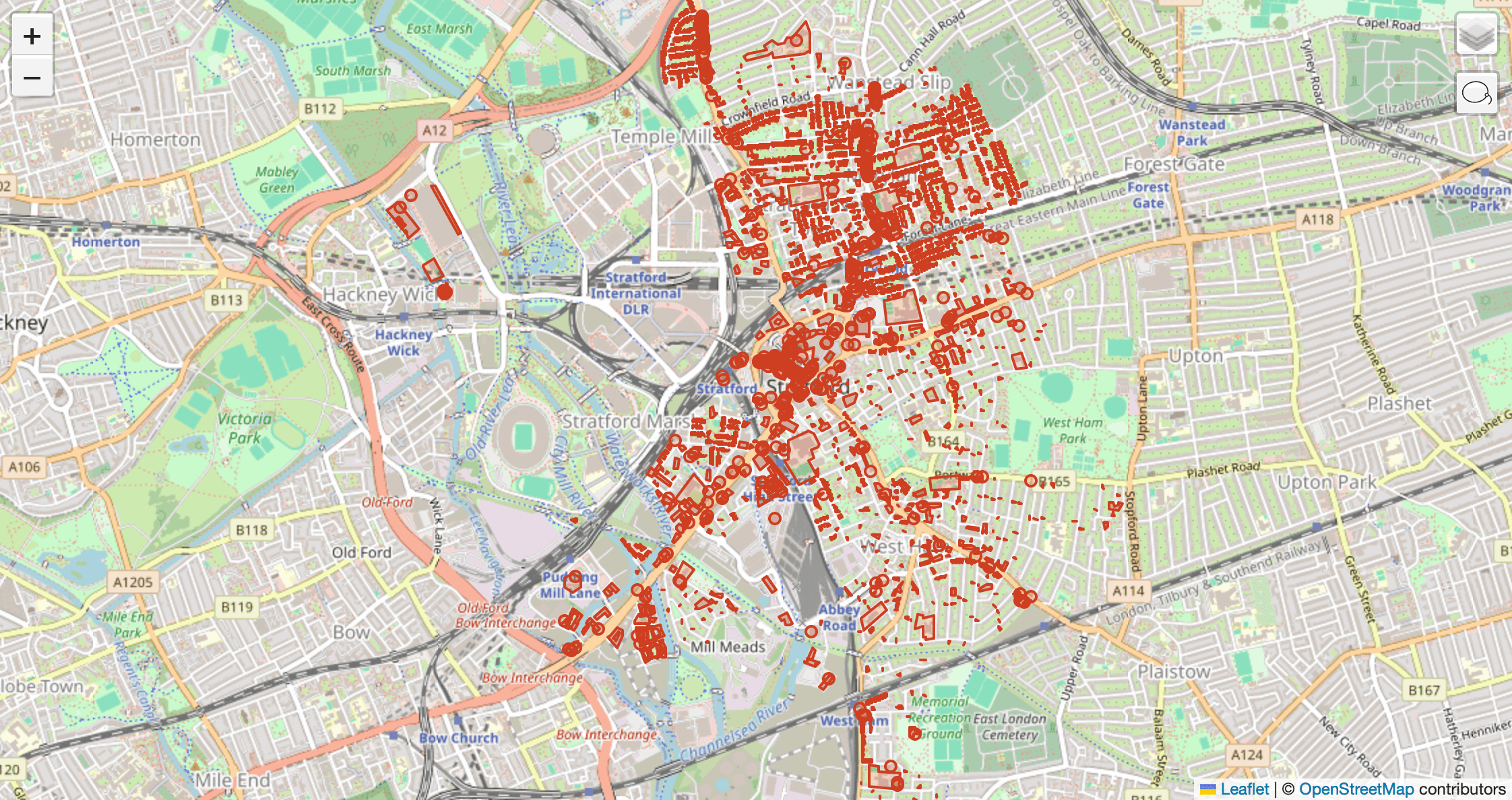
Gathering Postcode Locations: First, we obtained all the postcode locations associated with a specific outward code. For example, for the outward code "E15," we collected the geographic coordinates of all individual postcodes starting with "E15."
-
Identifying Buildings: Next, we retrieved all buildings that have outward postcodes. This provided a detailed set of points representing the buildings within the E15 area.

-
Calculating Convex Hull: Finally, we used these points to calculate the convex hull for both sets of geometries (postcodes and buildings). The convex hull is the smallest polygon that can contain all the points, providing a clear boundary for the outward postcode area.
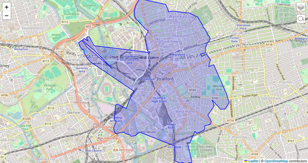


Because of the nature of postcodes, which are not always grouped by location, the boundaries may intersect each other. This means that some postcode areas can overlap, reflecting the real-world distribution of addresses.
By using this method, we ensured that the boundaries accurately reflect the geographic distribution of postcodes and buildings within each outward code area.
This dataset allows developers and analysts to integrate detailed postcode boundary information into their applications, enhancing the accuracy of geospatial analysis and supporting various projects.
Use Cases for Downloadable Resources
The downloadable postcode and post town datasets provide valuable information for a variety of applications. While the boundaries may not be highly precise and may intersect due to the nature of postcodes, they still offer significant benefits. Here are some common use cases:
-
Logistics and Delivery Services: Companies can enhance delivery routes and improve efficiency by using postcode and post town data. Even with some imprecision, the data provides a robust framework for planning routes and managing deliveries effectively.
-
Geospatial Analysis: Analysts can utilize postcode boundaries and post town data for geographic and demographic studies. The data is invaluable for broad analyses such as urban planning, market research, and resource allocation, despite minor overlaps.
-
Emergency Services: Emergency response teams can benefit from postcode and post town boundaries to locate addresses and plan routes. While not exact, the data gives a good approximation that aids in efficient emergency response planning.
-
Marketing and Sales: Businesses can target specific geographic areas for marketing campaigns using postcode data. The general distribution of postcodes helps identify potential markets and customer segments, providing strategic insights.
-
Real Estate: Real estate companies can provide information about properties and their approximate locations using postcode and boundary data. This data helps potential buyers get a clear understanding of the area and nearby amenities, enhancing the decision-making process.
-
Public Services: Local governments and public service providers can use the data to plan and manage services such as waste collection, public transport, and community resources. The data supports efficient service delivery planning, offering a useful overview despite some inaccuracies.
-
Navigation and Mapping: Developers of navigation systems and mapping applications can integrate postcode data to enhance their services. The data improves user experience by providing general location details, contributing to more accurate and reliable navigation tools.
By leveraging these datasets, organizations across various sectors can significantly improve their operations, enhance decision-making, and provide better services to their customers and communities. The data offers a valuable resource, making a positive impact even with its limitations.
Conclusion
Accurate postcode data is essential for various applications, from logistics to geospatial analysis. While accessing precise UK postcode data from Royal Mail poses challenges, alternative sources like OpenStreetMap and GeoNames provide valuable, freely available datasets.
This article explored UK postcode structure, the challenges of obtaining accurate data, and methodologies for creating boundaries for outward postcodes and post towns. By leveraging open data initiatives and tools like the Geoapify Geocoding API, developers and analysts can overcome these challenges.
The downloadable resources, despite some limitations in precision, offer significant benefits for enhancing efficiency, decision-making, and service delivery across various sectors. Embracing these solutions allows for innovation and improved outcomes, showcasing the power of open data.