Place Details API: Get Details and Surroundings for Any Place
Get everything about one place in a single request: name, address, contacts, opening hours, facilities and geometry, the building it's in, and what is around it — places within a radius, a walk or a drive.
Look a place up by its place_id or by coordinates. Click any place on the map below and switch between features to see what the API returns.
Place Details API returns details for a place found with the Geocoding API, Address Autocomplete or the Places API — pass its place_id — or for any location by coordinates, like reverse geocoding with much more data.
You choose what to get with features: the place's details, its building, and the places around it. For many places at once, run Place Details through the Batch API.
Get an API key and start for free — the Free plan includes 3,000 credits per day. Try the features in the Playground.
On this page
Data available with Place Details API
Request only the data you need: each feature returns one aspect of the place.
The table shows the main feature groups. See the full list of features >>
| Feature | Description |
|---|---|
details | Returns what is known about the place: names, website, contact data, opening hours, facilities, restrictions and category-related data (for example, parking capacity or restaurant cuisine). Returned by default. See all output fields >> |
details.population, details.names, details.full_geometry | Add population by year, international names, or the original (full) geometry to the details. |
building, building.places, building.commercial, building.catering | Return information about the building where the place is located. Additionally, with building.places, building.commercial and other features you can query places located in the same building. |
radius_100, radius_500, radius_1000 and radius_500.supermarket, radius_1000.pharmacy, ... | Return a circle around the place and the places of a category inside it. |
walk_5 … walk_30, drive_5 … drive_15 and walk_10.cafe, walk_15.hotel, drive_5.fuel, ... | Return the area reachable on foot or by car (an isochrone) and the places of a category inside it. For example, drive_5.fuel returns the 5-minute drive area and every fuel station in it. |
The list of features keeps growing. Contact us if you need one that isn't there yet.
Place Details API vs Places API (nearby search)
Both APIs return places, but they answer different questions. The Places API searches many places by category in an area. Place Details API returns everything about one place you already know, and optionally what is around it.
| Places API | Place Details API | |
|---|---|---|
| Question | "Which cafés are in this area?" | "What is this place, and what's around it?" |
| Input | Categories and an area: circle, rectangle, city, or an isoline | One place_id or a lat/lon |
| Returns | A list of matching places | The place's details, its building, and places within a radius, walk or drive |
| Typical use | Search results, map layers, store locators | A place page, a "nearby" section, a hotel or venue profile |
A common flow uses both: the Places API fills a list or a map, and when the user opens one result, Place Details API loads its full profile and surroundings.
Request example
One request returns the place, its 10-minute walking area and every place to eat inside it. The example looks up La Fonda on the Plaza, a hotel in Santa Fe, New Mexico, by its place_id:
https://api.geoapify.com/v2/place-details?id=514e1bb450007c5ac059ac254620ded74140f00102f9017290392b000000009203154c6120466f6e6461206f6e2074686520506c617a61&features=details,walk_10,walk_10.restaurant&apiKey=YOUR_API_KEYThe response is a GeoJSON FeatureCollection. Each feature has a feature_type: one details feature, one walk_10 area, and one feature per place found (65 places to eat in this case). A shortened response:
{
  "type": "FeatureCollection",
  "features": [
    {
      "type": "Feature",
      "properties": {
        "feature_type": "details",
        "name": "La Fonda on the Plaza",
        "categories": ["accommodation", "accommodation.hotel"],
        "address_line2": "100 East San Francisco Street, Santa Fe, NM 87501, United States of America",
        "place_id": "..."
      },
      "geometry": { "type": "Point", "coordinates": [-105.9375192, 35.6864663] }
    },
    {
      "type": "Feature",
      "properties": { "feature_type": "walk_10", "mode": "walk", "type": "time", "range": 600 },
      "geometry": { "type": "MultiPolygon", "coordinates": [ ... ] }
    },
    {
      "type": "Feature",
      "properties": {
        "feature_type": "walk_10.restaurant",
        "name": "The Shed",
        "categories": ["catering", "catering.restaurant", "catering.restaurant.mexican"],
        "formatted": "The Shed, 113 East Palace Avenue, Santa Fe, NM 87501, United States of America"
      },
      "geometry": { "type": "Point", "coordinates": [-105.9369913, 35.6874544] }
    }
  ]
}
This request costs 7 credits: 1 for details, 2 for the 10-minute walking area, and 4 for 65 places (1 credit per 20). See Pricing for the rules, and try your own place in the Playground.
Use cases and examples


Tell more about the place
Depending on the type of place, the API returns different information that is useful for your customers. For example, the details of a restaurant can include:
- Opening hours
- Contact data and website
- Type of cuisine
- Payment methods
Add neighborhood features to show more. For example, the drive_5.parking feature returns parking options within a 5-minute drive.
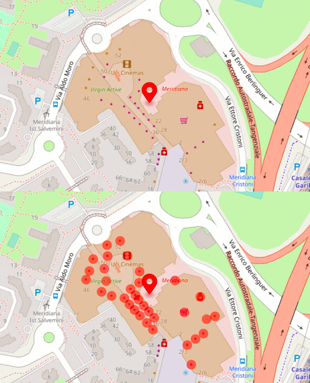
More information about building and amenities located there
Place Details API returns the building at the given location or the building that contains the given place. For example, a building's data can include:
- Building geometry, area
- Building characteristics - number of levels, type of roof, architecture information
- Infrastructure and objects within the building
Ask for the places inside it with building features. For example, building.catering returns all restaurants, cafés and bars in the building.


Show regions and statistical data
Place Details API can return boundaries and statistics for regions. For example, the details of a city contain its boundary, and the details.population feature adds population by year. For administrative boundaries at every level, see the Boundaries API.
Contact us when you need some specific data for regions and populated places.
Place details for destination guides
A hotel, museum or venue page answers two questions: what is this place? and what is around it? One Place Details request answers both, so a destination guide can show real numbers instead of "close to everything".
For example, the request above for La Fonda on the Plaza in Santa Fe returns the hotel's card (name, category, address) and the real 10-minute walking area around it, shaped by the streets of the historic downtown. Adding walk_10.cafe and walk_10.tourism to the same request gives a complete "nearby" section. Checked on October 6, 2026:
| Within a 10-minute walk | Feature | Places |
|---|---|---|
| Places to eat | walk_10.restaurant | 65 (63 restaurants and 2 fast-food places) |
| Cafés | walk_10.cafe | 17 |
| Points of interest for visitors | walk_10.tourism | 100 or more (the Palace of the Governors, historic houses and buildings, monuments) |
Two tips for honest guide pages:
- Name categories by what they contain.
walk_10.restaurantincludes fast food, so "places to eat" is the accurate label;walk_10.tourismmixes major sights with historic houses, plaques and unnamed objects (29 of the 100 here have no name), so pick named highlights rather than calling everything a sight. - Treat 100 as "100 or more". Each place feature returns up to 100 places, so a count of exactly 100 — like the points of interest here — is not the total.
See how travel and hospitality teams use location data on the tourism page.
Place Details API tutorials
These tutorials use Place Details API in real projects:


12 Essential Python Libraries for Geospatial Data Analysis (with Hands-On Examples)


UK Postcodes: Format, Challenges, and Downloadable Resources


Thematic Maps Guide: Definition, Different Types, Use Cases and Examples
How Much Does It Cost To Use the Geoapify Place Details API?
Place Details API uses credits, and a request's cost is the sum of the features you ask for:
| Feature | Cost |
|---|---|
details (returned by default) | 1 credit |
details.population, details.names, details.full_geometry, building | 1 credit each |
walk_5 … walk_30, drive_5 … drive_15 (the area) | 1 credit per 5 minutes: walk_10 = 2 credits |
radius_100, radius_500, radius_1000 (the circle) | free |
Places inside an area or building (walk_10.cafe, radius_500.atm, building.places, …) | 1 credit per 20 places returned |
Examples:
- Details only: 1 credit.
- Details and a 10-minute walking area: 1 + 2 = 3 credits.
- Details, the walking area and 65 places to eat in it (the request example): 1 + 2 + 4 = 7 credits.
- A full neighborhood profile with a 500 m radius, a 10-minute walk and a 5-minute drive, each with several categories: about 20 credits (worked example in the docs).
The Free plan includes 3,000 credits per day, enough for about 1,000 requests with details and a walking area. Estimate your volume with the credits calculator and compare plans on the Pricing page.
FAQ
What is the difference between Place Details API and Places API?
The Places API searches many places by category in an area, for example all cafés in a city district. Place Details API returns everything about one place you already know, by place_id or coordinates, and optionally the places around it within a radius, a walk or a drive.
How do I get place details by place ID or by coordinates?
Send GET https://api.geoapify.com/v2/place-details?id=PLACE_ID&apiKey=YOUR_API_KEY with a place_id from a Geocoding, Autocomplete or Places result, or use lat=…&lon=… instead of id. Add features=… to choose the data. See the API reference.
Can I get places within walking distance of a place?
Yes. Request a walking area (walk_5, walk_10, walk_15 or walk_30) and a category inside it, for example walk_10.cafe or walk_15.hotel. The response contains the reachable area and every matching place. Driving areas (drive_5 to drive_15) and circles (radius_100 to radius_1000) work the same way.
What kind of data does the Place Details API return?
The Place Details API returns the data depending on the place category and data availability. For example, for a parking place the result may contain "Parking capacity", access information and price, for a heritage place - build year, heritage operator, and level. Check the list of the fields on the documentation page.
Can I use the Place Id from Google Maps API to get information about the place?
No. Place Details API works with the place_id values returned by Geoapify APIs: the Geocoding API, Address Autocomplete and the Places API. You can also look up any place by its coordinates instead of an ID.
How is the Place Details API billed?
In credits, as the sum of the requested features: details costs 1 credit, a walking or driving area 1 credit per 5 minutes (walk_10 = 2 credits), and places inside an area 1 credit per 20 places returned. A request with details and a 10-minute walking area costs 3 credits.
See the pricing rules in the documentation and estimate your volume with the credits calculator.
Which data sources do you use for the Place Details API?
At the moment we use the OpenStreetMap database and Wikidata as data sources. However, we plan to extend the list. Contact us if your business case is not covered by the API.
Which data format do you use for the Place Details API?
We return data in GeoJSON format as a FeatureCollection, which is natively supported by most client libraries. Here you can find examples of how to visualize the features returned >>


