


Isochrone maps sound like a thoroughly digital invention, but these varieties of isoline maps have been around since the 1880s. They show you how far you can get from a specific destination in a specific time. You can specify travel type, such as walking time, driving time, or public transit time.
You can try creating isochrones with the CommuteTimeMap website, which uses Geoapify's Isolines API.
Isochrone maps have lots of uses:
- You might want to know how many shops are in fifteen minutes walking distance from your office.
- Or maybe you want to show your customers how many tourist attractions are within an hour's drive of your hotel.
- House hunters can look for a property that's thirty minutes or less public transit time from their work. With 85% of homeowners saying location is the most important factor when choosing a home, estate agents can stand out from the competition by providing up to date travel time information.
- Businesses can scout out new locations within a certain time of public transport hubs
Isochrone maps sound like a thoroughly digital invention, but these varieties of isoline maps have been around since the 1880s.
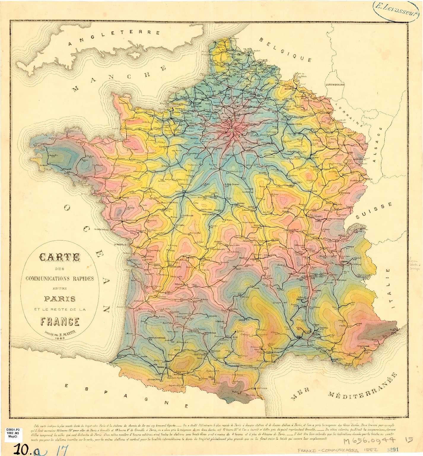
A colorful isochrone map from 1882, showing travel times to and from Paris. The map is a pale cream color, with isochrone areas marked in shades of blue, yellow, and pink. The original can be found here.
What do you actually see on a distance time map? An isochrone map contains a polygon that corresponds to the required travel time. So you might have a polygon that shows places you can reach within 20 minutes drive of Pinner,, London, like this:
An image of an isochrone map showing what is reachable in 20 minutes driving time of Marsh Road, Pinner, London. The isochrone is shown in purple.
You'll notice that isochrones don't just show a circle, which wouldn't be as accurate. Isochrone maps show a polygon that translates to real travel time.
The isochrone's shape also tells you something about the conditions in the area. An almost round isochrone shows a well-developed area that is most likely easy to walk or drive. But an isochrone that looks more like a tunnel hints at a less developed area, or one where routes are narrowed by features such as mountains or national parks. But what does all this mean for your business? Let's dive deeper.
How do isochrone maps work?
An isochrone is a line connecting points that exist in a pre-defined time frame. For example, an isochrone might show all points that can be reached in X number of driving minutes from point A.
You can build isochrone maps that take into account conditions affecting travel time. This is much more accurate than a map that assumes travel time conditions are always the same.
Conditions that can affect travel time include:
- Traffic conditions such as rush hour
- Geography such as steep inclines
- Available routes (such as cycling paths or train lines)
Say you've got a shoe store and you want to open a new location. You want to know how long it will take your staff to reach the store, to be sure the location is viable.
The area to the east of the store is more built up, with stop lights, intersections, and more traffic at rush hour. The area to the west is less built up, and the roads aren't as busy. Staff traveling from ten miles to the east will take longer than those traveling from ten miles to the west. A distance time map can allow for that, so you can chose the most reachable location.
What are examples and use cases of isochrone maps?
CommuteTimeMap lets you build isolines that show what you can reach in a certain amount of time from your starting point. Let's take a look at what it can do.
Discover hidden locations
Amily and her family are currently renting a home in Munich, and looking to buy a home of their own. But Amily is struggling to find properties in her price range within reach of her work on public transport. She's ready to give up, when a colleague tells her about isochrones. She creates an isochronic map that shows locations within an hours public transit time of her office. The map shows some hidden gems that she hadn't even thought of, where property is affordable. Now Amily lives in a home she loves, and has an easy commute where she can sleep or catch up with work on the train.
This map shows the area of Munich that can be reached by public transportation.
Find amenities
Ethan is looking for a swimming pool that's easy to get to from his home. He decides that a 20 minute walk or 10 minute bicycle ride is the ideal distance - more than that and he won't have the time and energy to enjoy his swim! With isochrones he can put in his location and find all areas reachable by 20 minutes on foot or 10 minutes on his bike. And he can check out swimming pools in those areas.
This map shows the areas in London that you can reach within 20 minutes on foot, and also areas that can be reached in 10 minutes by bicycle.
Plan leisure trips
Chidi is taking his family to Austria for a skiing holiday at the Obertauern ski resort. They're excited to hit the slopes and want to make sure they won't waste too much time traveling to and from their hotel. They decide they want to stay within a 10 minute walk of the ski lift station. With a distance time map they can see how far they could walk in 10 minutes, and choose a hotel that gives them maximum skiing time.
A 10-minute walk isochrone from the ski lifts at Obertauern, Austria.
Find places that suit more than one person's needs
Ingrid and Pierre are looking for a new apartment to live in. But they both work in different parts of Paris and are worried about finding somewhere they can both commute from.
They can use isochrone intersections to find areas that are reachable from multiple places. First, they look for what can be reached within 30 minutes on public transport from Ingrid's restaurant. Next they search for locations reachable in the same time frame from Pierre's theater. Now they can see the intersection, where an area is reachable from both their work places. Choosing an apartment just got much easier.
A 10-minute walk isochrone from the ski lifts at Obertauern, Austria.
What if I need to create more complex isochrone maps?
A service like CommuteTimeMap works great to answer simple “where can I get to from this location, in X amount of time, using this mode of travel?” questions.
But to harness the power of isochronic maps in your business, you need a business-focused solution. One that lets you enter thousands of inputs at once.
That's where our isochrone map generator comes in. Use it to create multiple isochrones and analyze locations. Use the intersection or union of isochrones to create multi-point maps to provide services to your customers, or make better business decisions.
Try out our API to calculate isochrones intersections and unions.
How can isochrone maps benefit my business?
Isochrone maps offer lots of benefits for your business, from creating applications for your customers, to gathering location intelligence. Here are just a few ideas:
- Estate agents can help clients find homes within a certain distance of work, schools, or amenities
- Tourist attractions can help customers find hotels or amenities within a certain travel time. And hotels can help customers find tourist attractions nearby. With more than 60% of travelers saying that taking time to research a trip is more important than ever, helping your customers do that research will make you stand out.
- Brick and mortar stores or restaurants can help customers find locations within a certain travel time of their home or hotel.
- Businesses can help staff plan their commute.
- Urban planners can find optimum locations for new buildings or public transport hubs and routes.
How can I use isochrone maps to improve customer experience?
Isochrone maps help you improve customer experiences. Use isochrones to help your customers learn about travel times from a certain point. Whether you're showing them homes near their workplace or tourist attractions near your resort, you're making their life easier.
An isochronic map can keep your customers on your website. They can scout out potential homes, places to stay, or attractions to visit. They can filter by their desired parameters and get all the information they need. And all without needing to navigate away.
Using isochrone maps makes it easy for your customers to figure out what is reachable in just a few clicks. From looking for a new home to planning a vacation, they know they can rely on you. You'll stand out in their mind as a business they can trust.
How can I use isochrone maps to make better business decisions?
You can also use isochrone maps behind the scenes to make better business decisions. Before investing in a new location, use an isochrone map generator to examine it:
- Warehouses and logistics centers can analyze locations to find the one that will let them reach the most customers in the least amount of time.
- Stores and offices can research if a location is reachable for enough customers or staff.
- You can combine demographic data with the isochrone results to find out if there are enough of your target customers near your proposed location.
- See if a proposed location has got good enough public transport
Isochrone maps can help with marketing too. When you combine them with demographic information you can see where most of your customers are, and which locations are most reachable for them. Use that intel to decide on the location of physical advertisements.
Hiring new staff? Use reachability information from isochrone maps to place recruitment advertisements in the best catchment areas. With one survey finding that one in three people had passed up a dream job because the travel time was too long, knowing reachability ahead of time is important.
Because isochrone maps display all reachable areas that fit your parameters, they can also turn up hidden locations you weren't aware of before.
How does Geoapify make it easy to calculate travel times?
Calculating isochrones is complicated. First the program or site you're using needs to generate oll the possible routes from a location. Then it will narrow them down to the routes that match your desired travel time and mode of transport. And after all that, it needs to combine all that information into isochrone geometry.
Thankfully, our isochrone map generator makes calculating isochrones quick and easy. We based our Isoline API on OpenStreetMap, which is the most up-to-date geodata source. And we run our API on dozens of high-performance servers that can scale dynamically, making sure our system is stable and reliable.
Put in your location, desired travel time, and travel mode, and the API create an isochrone for you.
Which travel modes and restrictions can I use for isochrone maps?
Our API makes it easy to create highly specific maps. You can choose from a wide range of travel modes, including:
- Driving
- Walking
- Hiking
- Cycling
- Public transport
The type of vehicle you're using can also make a difference. Our API lets you specify the type of vehicle, including light, medium and heavy trucks, scooters, motorbikes, long trucks or those carrying dangerous goods. Check out the full list here.
You can allow for route restrictions too. Avoid tolls, highways and ferries. Allow for traffic conditions, or specify whether you want a balanced route, shortest route, or one with less maneuvers.
How can I integrate isochrone maps with my website or application?
It's easy to create maps with Geoapify, then integrate them with your website or app.
Our Isochrone API returns isochrone geometry. You can call the API with JavaScript which can be used with any website builder technology:
//generate an 30 min bicycle isochrone from Philadelphia, United States of America
fetch(`https://api.geoapify.com/v1/isoline?lat=39.9782041&lon=-75.1948359&type=distance&mode=bicycle&range=30000&apiKey=${myAPIKey}`)
  .then((data) => data.json())
  .then((isochroneGeoJSON) => {
    // here you get an isochrone data
    console.log(isochroneGeoJSON);
  });
Once you've called the API, you can visualize the isochrone geometry on a map. For example, here's how you can visualize the geometry with Leaflet map:
L.geoJSON(isochroneGeoJSON, {
  style: (feature) => {
    return {
      stroke: true,
      color: '#9933ff',
      weight: 2,
      opacity: 0.7,
      fill: true,
      fillColor: '#333399',
      fillOpacity: 0.15,
      smoothFactor: 0.5,
      interactive: false,
    };
  },
}).addTo(map);
Complete code sample on JSFiddle >>
And here's how you can visualize the geometry with MaplibreGL map:
map.addSource(sourceId, {
  type: 'geojson',
  data: isochroneGeoJSON,
});

// add contour
map.addLayer({
  id: lineLayerId,
  type: 'line',
  source: sourceId,
  layout: {
    'line-join': 'round',
    'line-cap': 'round',
  },
  paint: {
    'line-color': '#ff69b4',
    'line-width': 3,
  },
});

// add filling
map.addLayer({
  id: fillLayerId,
  type: 'fill',
  source: sourceId,
  paint: {
    'fill-color': '#ff69b4',
    'fill-opacity': 0.1,
  },
});
Complete code sample on JSFiddle >>
Which countries can I create isochrone maps for?
You can use CommuteTimeMap and our Isolines API to create maps worldwide.
An isochrone map showing Johannesburg, SA
An isochrone map showing what is reachable in 60 minutes public transit time of Boundary Road, Johannesburg, SA.
An isochrone map around Sydney Airport International Terminal
An isochrone map showing what is reachable in 30 minutes driving time of Sydney International Airport, International Terminal, Australia.
An isochrone map showing Lake Shore Drive, Chicago
An isochrone map showing what is reachable in 15 minutes truck driving time of Lake Shore Drive, Chicago, IL.
What is an isochrone in GIS?
Experts can use isochrones to analyze locations in a GIS (Geographic Information System.) When time is an important factor, isochrones help professionals with planning and analytics.
GIS professionals have a lot of statistical data at their fingertips. When they combine that data with isochrones they can get more detailed results and generate visualizations that help answer a wide range of questions.
What are the limitations of isochrone maps?
Because isochrone maps deal strictly with time, not distance, you can't use them to track distances. So for example if you need to log miles for a gas mileage claim, you will need to use another tool, such as an isodistance map.
You can use our Isolines APi to generate isodistances, too. Try it here >>
Ready to explore what isochrone maps can do for your business? Learn more and try out our Isoline API for yourself here. You can get started for free.