


Which areas can I reach from a city center within 30 min by public transport? Where can I drive from my home within 1 hour? Or in other words, how far can I go from a location within a certain amount of time? This is the questions a travel time map or isochrone answer.
An isochrone is a line (or multiple lines) on a map, which bounds all possible locations reachable from a location within a given time. For example, it could all the places you can get from your working place within 30 min.
Transportation Modes for travel time maps
You can build an isochrone for different transportation modes and different speed levels. For example, driving, bicycle, walking or public transport. An algorithm checks all possible roads and trails and checks public transport schedules to calculate an isochrone for you. As a result, you get a highlighted area on the map which visualizes all areas accessible from a location by chosen transportation.
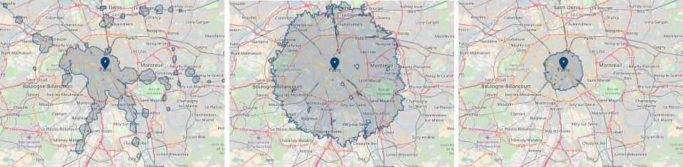
The form of travel time maps for different modes could look completely different. For example, 45 minutes isochrones for Paris below have various size and form.
Make a location decision with isochrones
Firstly, a travel time map visualizes how good is the connectivity of a place. In other words, it shows on the map if the place is easy to reach from different locations. Bigger the area of isochrone, the better connection it has. This might be useful when choosing a place for a new retail show or office.
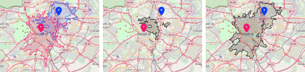
Secondly, unions or intersections of isochrones could show hidden and often underrated spots on the map. So with an intersection, you can see areas reachable from multiple locations. This could be used when looking for a place with a good connection to multiple points of interest.
And unions show coverage for a location network. This could help to find a place for a new uncovered location to extend the retail network, for example.
Isoline API from Geoapify
Geoapify offers Isoline API to build travel time maps and provide operations on them. We support drive, bicycle, walking modes as well as transit mode for public transport. You can perform geometry operations like intersection or union on pair or multiple isochrones.
Register and try the Isochrone API now for free!