


On this page
OpenStreetMap (OSM) is a global, editable map created and maintained by a vast community of contributors. You can fix errors, add new locations, and help improve the map — all under an open license. With millions of users and contributors, OSM has become one of the most up-to-date and detailed sources of geographic data available.
Thanks to its richness and openness, OSM is widely used by developers who need high-quality mapping data for apps, websites, and research. However, working with raw OSM data can be complex — it often requires specialized tools and knowledge to extract and convert the data into usable formats.
In this article, we'll explore three simple ways to access OpenStreetMap data, including how to easily query it using the Geoapify Places API.
What Kind of Geodata Is Available in OpenStreetMap?
OpenStreetMap offers a vast and diverse collection of geographic data — from administrative boundaries and major roads to smaller features like benches, trees, and post boxes. It includes not only visible elements on the map but also detailed metadata about places. For example, you might find the number of floors in a building, website URLs, opening hours, and other useful attributes.
OSM features are described using a flexible system of tags, which consist of key–value pairs. You can browse all commonly used tags and their meanings on the TagInfo website.
To explore the data available in your area or for your specific use case, we recommend starting with the OpenStreetMap website:
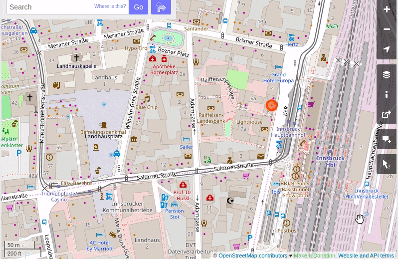
- Zoom in to your region of interest
- Click on the “Query features” tool in the sidebar
- Click anywhere on the map to view detailed information about the features at that location
This is a great way to get a feel for the richness and structure of OSM data before diving into extraction methods.
OpenStreetMap Data Structure
Before we dive into data extraction and query examples, it's important to understand how OpenStreetMap data is structured. This foundational knowledge will help you make sense of the data you retrieve.
OpenStreetMap consists of three core object types: nodes, ways, and relations. Each object has a unique identifier (osm_id) and a type (osm_type). For example, an object might be defined as osm_type="way" with osm_id=67104773.
Each object can also have a set of tags — key-value pairs that describe its attributes, such as the address, opening hours, feature type, or even external references like Wikipedia pages.
Nodes
Nodes are the simplest OSM elements. They represent a single point defined by geographic coordinates (latitude and longitude). A node can represent features such as a tree, postbox, subway entrance, city center, or building number.
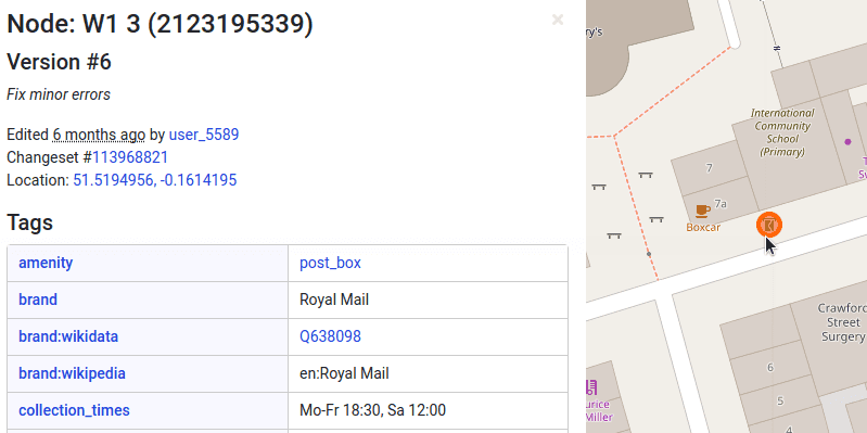
Nodes can be standalone or part of larger structures like ways and relations. For example, a subway entrance might be both an individual node and a member of a subway station relation.
Ways
Ways are ordered lists of nodes that form either a line (open way) or a polygon (closed way). They are used to represent linear or area features like streets, rivers, buildings, and boundaries.
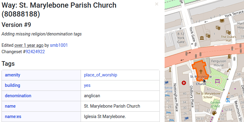
Like nodes, ways can be independent or part of a relation. In many cases, a single street or river is made up of multiple connected ways, allowing each segment to carry specific tags such as surface type, speed limit, or number of lanes.
Relations
Relations are complex structures that group together multiple nodes, ways, or other relations to represent a logical or geographic relationship. For example, a relation can define a cycle route, a public transport route, or a multipolygon boundary.
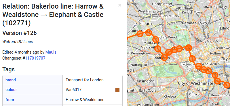
Relations also support tags — often called "tags on relation" — that describe properties of the group as a whole, rather than its individual members.
Tags
Tags are what give meaning to OSM objects. Each tag is a key–value pair, like building=yes or name=Old Marylebone Town Hall. Here’s an example of how tags might describe a building:
building=yes– Identifies the object as a buildingname=Old Marylebone Town Hall– The building’s nameoperator=Westminster City Council– Who operates the buildingaddr:street=Marylebone Road– The street address
Tags are extremely flexible and community-driven. You can browse commonly used tags on the TagInfo portal, which includes usage stats, tag meanings, and examples.
The OSM community maintains guidelines for how features should be tagged to promote consistency across the global dataset. These are often referred to as the OSM Map Features or the "style guide" — essential for ensuring that applications using OSM data produce coherent and predictable results.
Ways to Extract OpenStreetMap Data
There are several ways to retrieve data from the OpenStreetMap (OSM) project and use it in your applications. Let’s explore the most common methods — from raw data snapshots to ready-to-use APIs.
Option 1: Download OSM Data Snapshots
The original OSM files are provided in an XML-based format. This format is designed to store information about nodes, ways, and relations, including a complete history of map edits.
However, for reading and processing OSM data more efficiently, it's recommended to use alternative formats like PBF, which are supported by various third-party tools and extractors.
Download from Planet OSM
Planet OSM provides full weekly snapshots of the entire OSM database. These snapshots contain all data available at the time of the export.
To work with the data, you can use tools like Osm2pgsql to import OSM files into a PostGIS database. Once imported, you can write SQL queries to extract and analyze geographic data.
For example, this SQL query retrieves all restaurants in a bounding box over Paris:
WITH filterGeom AS (
  SELECT ST_Transform(
           ST_SetSRID(
             ST_GeomFromGeoJSON('{"type":"Polygon","coordinates":[[[2.2795, 48.8810], [2.4142, 48.8810], [2.4142, 48.8325], [2.2795, 48.8325], [2.2795, 48.8810]]]}'),
             4326
           ),
         3857) AS w
)
SELECT
  pop.osm_id,
  pop.tags,
  'node' AS osm_type,
  ST_AsGeoJSON(ST_Transform(way, 4326))::jsonb AS geojson
FROM planet_osm_point pop, filterGeom
WHERE pop.amenity = 'restaurant' AND ST_Intersects(way, filterGeom.w)
UNION ALL
SELECT
  pol.osm_id,
  pol.tags,
  'polygon' AS osm_type,
  ST_AsGeoJSON(ST_Transform(way, 4326))::jsonb AS geojson
FROM planet_osm_polygon pol, filterGeom
WHERE pol.amenity = 'restaurant' AND ST_Intersects(way, filterGeom.w);
Note: some restaurants are stored as points (planet_osm_point), others as polygons (planet_osm_polygon). You must query both tables to cover all cases.
Download from Geofabrik
Geofabrik offers daily extracts of OSM data by continent, country, or region. Files are available in PBF format, already cleaned of sensitive metadata such as user IDs and changesets. This makes them ideal for use in commercial or production environments.
Download from BBBike
BBBike provides compact extracts (2–50 MB) for selected cities and regions. You can choose between various formats: PBF, XML, shapefiles, vector map tiles, and others — perfect for quick access to local datasets.
| Pros | Cons |
|---|---|
|
|
Option 2: Use Overpass API
The Overpass API allows you to query OSM data based on specific criteria. It supports two query languages: Overpass QL and Overpass XML.
You can test and refine your queries using Overpass Turbo, an interactive tool that displays query results on a map and supports features like query export, map zoom, and object editing.
Here’s a sample query to retrieve restaurants in Paris:
nw
  [amenity=restaurant]
  (48.8330,2.2792,48.8800,2.4140);
out;
Query tips:
- Use
node,way,relationto access individual object types. - Use combinations like
nw,nwr,wrto fetch multiple types in one request. - You don’t need to be an expert to write Overpass QL queries — you can use tools like ChatGPT to help generate or explain queries based on plain-language prompts.
There are multiple public Overpass API instances available, but free servers are subject to usage limits and are not suitable for high-volume or production usage. For commercial needs, contact Geoapify for dedicated access.
| Pros | Cons |
|---|---|
|
|
Option 3: Use Geoapify Places API – The Easiest Way
The Geoapify Places API is the most straightforward way to access OpenStreetMap data. You can search for places by category and location using a simple HTTP request — no need to worry about OSM internals like nodes, ways, or relations.
Here’s how to retrieve restaurant data for Paris using a single API call:
https://api.geoapify.com/v2/places?categories=catering.restaurant&filter=rect:2.2792,48.8330,2.4140,48.8800&limit=100&apiKey=YOUR_API_KEYYou can try this instantly using the API Playground.
In your JavaScript app, you can fetch data like this:
fetch('https://api.geoapify.com/v2/places?categories=catering.restaurant&filter=rect:2.2792,48.8330,2.4140,48.8800&limit=100&apiKey=YOUR_API_KEY')
  .then(resp => resp.json())
  .then((places) => {
    console.log(places);
  });
Geoapify handles all the complexity for you — it merges relevant OSM objects, validates data, and categorizes it. The API supports 500+ place categories, including accommodation, entertainment, retail, education, and more.
| Pros | Cons |
|---|---|
|
|
How Good Is the Quality of OSM Geodata?
OpenStreetMap (OSM) is one of the most detailed and dynamic geospatial databases available — but as a crowdsourced project, it comes with both strengths and limitations. Understanding these will help you make better use of OSM data in your projects.
Strengths of OSM Geodata
1. Up-to-date and detailed data Thanks to a large and active community, OSM data is often more current than commercial alternatives, especially in cities and regions with strong contributor networks.
2. Rich and flexible tagging system OSM uses a key–value tag model that allows detailed information to be stored for almost any feature — from benches and bike racks to building heights and access restrictions. You can explore tag usage via TagInfo or definitions on the OSM Wiki.
3. Constant quality improvement The community actively works to improve consistency and correctness through:
- Editing tools with validation (e.g., iD Editor, JOSM)
- Quality monitoring tools like OSM Inspector, Keep Right, and MapRoulette
- Global mapping campaigns and humanitarian efforts (e.g., HOT OSM)
Known Challenges and Limitations
1. Inconsistent data modeling Because OSM is contributed by thousands of people, features may be mapped differently depending on contributor habits, region, or tools:
- A restaurant might be mapped as a
node, away, or part of arelation - Tags like
shop=grocery,shop=supermarket, andamenity=marketplacemight describe similar concepts
2. Missing or outdated data In less-mapped or rural regions, some features might be completely missing or not recently updated.
3. No built-in schema enforcement Unlike traditional databases, OSM doesn’t enforce a fixed schema. While this gives contributors flexibility, it can lead to:
- Typos in tags (e.g.,
highwaay=primary) - Uncommon or ambiguous tag usage
- Difficulties in reliably querying across multiple regions
4. No guarantees on completeness or accuracy OSM makes no formal guarantee that data is complete or correct. Use of OSM in critical applications (e.g., emergency routing, compliance-heavy projects) should be combined with validation or cross-checking.
Dealing with Quality Issues
To handle OSM data effectively, you may need to:
- Post-process and normalize tags using tools like osmconvert/osmfilter or custom scripts
- Use cleaned, categorized data via APIs like Geoapify Places API that handle inconsistencies for you
- Monitor data changes with tools like Whodidit or Overpass Turbo to track updates
Tutorials and Related Posts
Want to dive deeper or see real-world examples? Here are some tutorials and articles that will help you explore OpenStreetMap data and learn how to use it effectively in your own projects.


How to get OSM Places by category for a region


Geoapify as an Alternative to Google Places API


Guide to Points of Interest (POI) Data - Definition, Use Cases and Where To Get POI Data
Conclusion
OpenStreetMap is a true game-changer in the world of geospatial data. Whether you're building an open-source project, a commercial app, or a data analysis pipeline — OSM gives you free, community-driven access to detailed and constantly updated map data.
In this article, you’ve learned about three effective ways to get OSM data into your project:
- Use data snapshots for full control and offline access
- Use Overpass API for filtered queries and flexible analysis
- Use Geoapify Places API for fast, ready-to-use location data with minimal setup
What Should You Use?
- If you’re a developer building a production app or frontend map, use the Geoapify Places API. It’s easy, clean, and optimized for real-world use.
- If you need raw data for a custom backend or GIS processing, download data snapshots from Geofabrik or Planet OSM.
- If you're a researcher or hobbyist exploring specific features, try Overpass Turbo for flexible ad hoc queries.
At Geoapify, we believe in the power of OpenStreetMap and love helping others make the most of it. If you need help choosing the right tool or integrating OSM data into your product, contact us — we’re happy to advise you on the best approach for your goals.
FAQ
Is OpenStreetMap data free to use?
Yes, OpenStreetMap (OSM) data is free under the Open Database License (ODbL). You can use, modify, and share it—even commercially—as long as you provide proper attribution and share derived databases under the same license.
Do I need to give credit when using OSM data?
Yes, attribution is required. A simple credit like © OpenStreetMap contributors is usually sufficient. Learn more on the OSM copyright page.
What formats are available for downloading OSM data?
You can download OSM data in OSM XML, PBF (Protocolbuffer Binary Format), shapefiles, GeoJSON, and more using tools and services like Geofabrik or BBBike.
Which method should I use to get OSM data?
It depends on your use case:
- For full offline datasets, use Planet OSM or Geofabrik.
- For small areas or filtered queries, use the Overpass API.
- For easy-to-use access, try the Geoapify Places API.
Is the data quality consistent across all regions?
Not entirely. OSM quality depends on the activity of local contributors. Urban areas often have high-quality, up-to-date data, while rural or less-mapped areas may have gaps. You can check and explore quality with tools like OSM Inspector and Keep Right.
What are nodes, ways, and relations in OSM?
These are the core data structures in OSM:
- Node: A single geographic point (e.g., a tree or bench).
- Way: A line or polygon formed by multiple nodes (e.g., a road or building).
- Relation: A group of nodes and/or ways that define complex structures (e.g., bus routes or multipolygons).
See the Elements documentation for more.
Can I use OSM data in browser-based apps?
Yes. While raw OSM data is too large and complex for frontend apps, you can use APIs like the Geoapify Places API that provide processed and categorized data suitable for client-side use.
Do I need to be an expert to query OSM data?
Not at all! You can use tools like Overpass Turbo for interactive queries, or ask ChatGPT to help you write and explain Overpass queries based on your needs.